Discover Parks & Wildlife contains affiliate links and is a member of the Amazon Services LLC Associates Program. If you make a purchase using one of the Amazon links, we may receive compensation at no extra cost to you. We may also use select AI tools to support our creative process, but all content is reviewed, refined, and finalized by our human team. See our disclosure policy and our AI use policy for more information.
12 Unbelievable Geological Wonders And Canyon Adventures For Your Bucket List
The natural world is full of striking landscapes that remind us of the immense power of time and geology. From water carving through solid rock to wind sculpting delicate spires, the forces of nature have created some truly surreal environments that almost defy explanation.
Visiting these sites isn’t just about seeing a pretty view, but rather connecting with the deep history of our planet. You can stand on the edge of a canyon that exposes millions of years of sedimentary layers or walk through a cave system that remains at a constant temperature regardless of the weather outside.
These destinations challenge our sense of scale and offer a perspective you simply cannot find in a city or a standard beach resort. And planning a trip to these locations requires a bit more preparation than your average vacation, as you often need to consider weather patterns, permit systems, and physical exertion levels.
However, the reward is gaining access to some of the most unique scenery on Earth.
This list highlights incredible formations and canyon experiences that deserve a prime spot on your travel itinerary, offering a mix of accessible viewpoints and challenging treks.
Antelope Canyon, Arizona

Located just east of Page, Antelope Canyon is perhaps the most famous slot canyon in the American Southwest. It is situated on Navajo land, which means you must visit with an authorized tour guide to enter the narrow, winding corridors.
The walls of Antelope Canyon were formed by the erosion of Navajo Sandstone, primarily due to flash flooding. Over countless years, rainwater running through the basin picked up speed and sand, smoothing the rock into the flowing shapes you see today.
The canyon is divided into two distinct sections known as Upper Antelope Canyon and Lower Antelope Canyon.
The Upper section is at ground level and requires no climbing, making it the more popular choice for casual visitors and photographers chasing the famous light beams. These ethereal shafts of light typically appear during the middle of the day between late March and early October, illuminating the swirling red sandstone walls with a divine glow.
Lower Antelope Canyon is physically more demanding to visit, requiring you to navigate several flights of stairs and narrow passageways. It is longer than the Upper section and creates a more intimate, adventurous experience.
Regardless of which section you choose, be prepared for crowds, as the beauty of these sculpted walls draws visitors from around the world.
Black Canyon Of The Gunnison National Park, Colorado

While it may not have the sheer width of the Grand Canyon, Black Canyon of the Gunnison in western Colorado is impressive for its incredible steepness and depth.
The Gunnison River drops an average of 43 feet per mile within the park, which is significantly steeper than the Colorado River’s drop through the Grand Canyon. This dramatic gradient has allowed the river to carve a gorge that plunges 2,722 feet at its deepest point at Warner Point.
In fact, the walls are so sheer, and the canyon so narrow, that some parts of the gorge floor receive only 33 minutes of sunlight a day, contributing to its shadowy, imposing name.
One of the most striking features here is the Painted Wall. Standing at 2,250 feet tall, it is the highest cliff in Colorado, surpassing famous landmarks like the Empire State Building in height. The wall gets its name from the lighter-colored pegmatite dikes that crisscross the dark metamorphic rock, creating a massive, natural mural.
You can experience the canyon from both the South Rim and the North Rim. The South Rim is open year-round and has a paved road with several overlooks, while the North Rim is accessible only on a gravel road and closes during the winter months.
For the truly adventurous, hiking to the inner canyon offers spectacular fishing and solitude, but the routes are strenuous and unmarked.
Bryce Canyon National Park, Utah
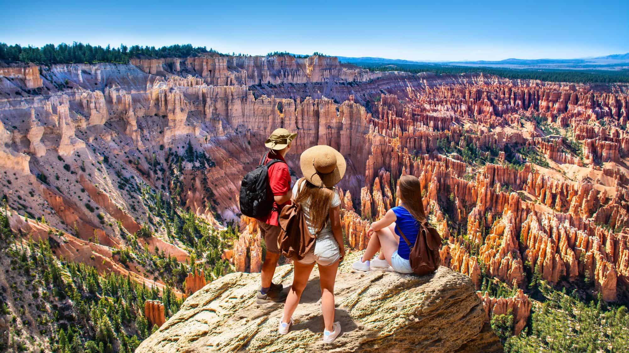
Bryce Canyon National Park is technically not a canyon at all, but rather a series of natural amphitheaters carved into the edge of a high plateau. The park sits at a high elevation, with the rim varying between 8,000 and 9,000 feet. This means the weather is often cooler than in nearby Zion or the Grand Canyon.
The defining feature of this landscape is the hoodoo, a tall, thin spire of rock that protrudes from the bottom of an arid drainage basin. Bryce Canyon actually contains the largest concentration of them found anywhere on Earth, creating a forest of stone that glows in shades of orange, red, and white.
These unique hoodoos are formed primarily by a process known as frost wedging. Water seeps into cracks in the rock, freezes at night, and expands, gradually breaking the rock apart over thousands of cycles.
You can view these formations from the rim trail, but hiking down into the amphitheater on the Queen’s Garden or Navajo Loop trails gives you a much better sense of their scale.
The park is also a designated International Dark Sky Park, making it an exceptional location for stargazing once the sun sets behind the plateau.
Delicate Arch, Utah

Standing as the iconic symbol of Utah, Delicate Arch is a freestanding natural arch located in Arches National Park. The opening beneath the arch is 46 feet high and 32 feet wide, framing the La Sal Mountains in the distance perfectly.
It is made of Entrada Sandstone, which has been eroded by wind and water over millions of years to create this precarious, gravity-defying form. And while the park contains over 2,000 documented natural stone arches, Delicate Arch is unique because it stands in isolation on the edge of a sandstone bowl, adding to its visual impact.
Reaching the arch requires a hike of about 3 miles round-trip with an elevation gain of 480 feet. The trail is completely exposed to the sun, so carrying plenty of water is essential, especially during the scorching summer months when temperatures often exceed 100°F.
The path takes you over slickrock where cairns mark the way, adding a slight element of route-finding to the adventure. Sunset is the most popular time to visit, as the fading light turns the orange sandstone a deep, fiery red.
However, visiting at sunrise offers a quieter experience and avoids the heat of the day. Just make sure to check the park’s website for timed entry reservations, as this destination sees heavy traffic during peak seasons.
Badlands National Park, South Dakota
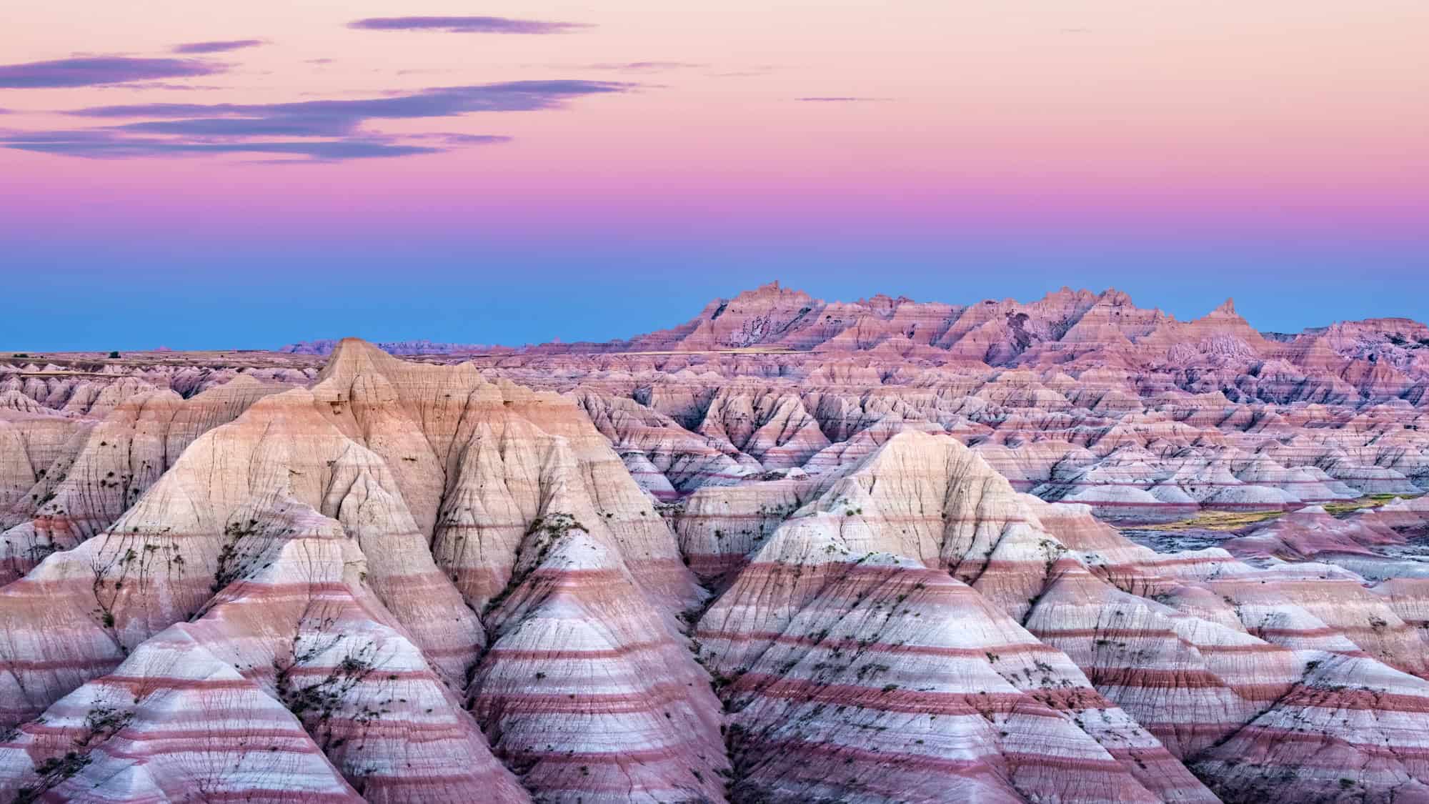
Badlands National Park protects 242,756 acres of sharply eroded buttes, pinnacles, and spires blended with the largest undisturbed mixed-grass prairie in the United States.
The landscape here feels alien, with bands of color streaking across the rugged formations, revealing different layers of sedimentary rock deposition.
It is a harsh environment where erosion carves the soft sedimentary rock at a rate of about one inch per year. This rapid erosion is constantly uncovering new fossils, making the park one of the world’s richest fossil beds from the Oligocene epoch, which occurred roughly 23 to 35 million years ago.
Visitors often spot wildlife such as bison, bighorn sheep, and prairie dogs while driving the 39-mile Badlands Loop Road. This scenic byway offers numerous overlooks and trailheads where you can get out and explore the terrain on foot.
The Door, Window, and Notch trails offer relatively short hikes that bring you right into the heart of the formations. But if you visit during the summer, be prepared for intense heat and sudden thunderstorms that can turn the clay soil into a slippery, impassable gumbo.
The park is surprisingly accessible otherwise, allowing you to see significant geological history without needing to venture far from your vehicle if you prefer a more relaxed visit.
The Subway, Utah
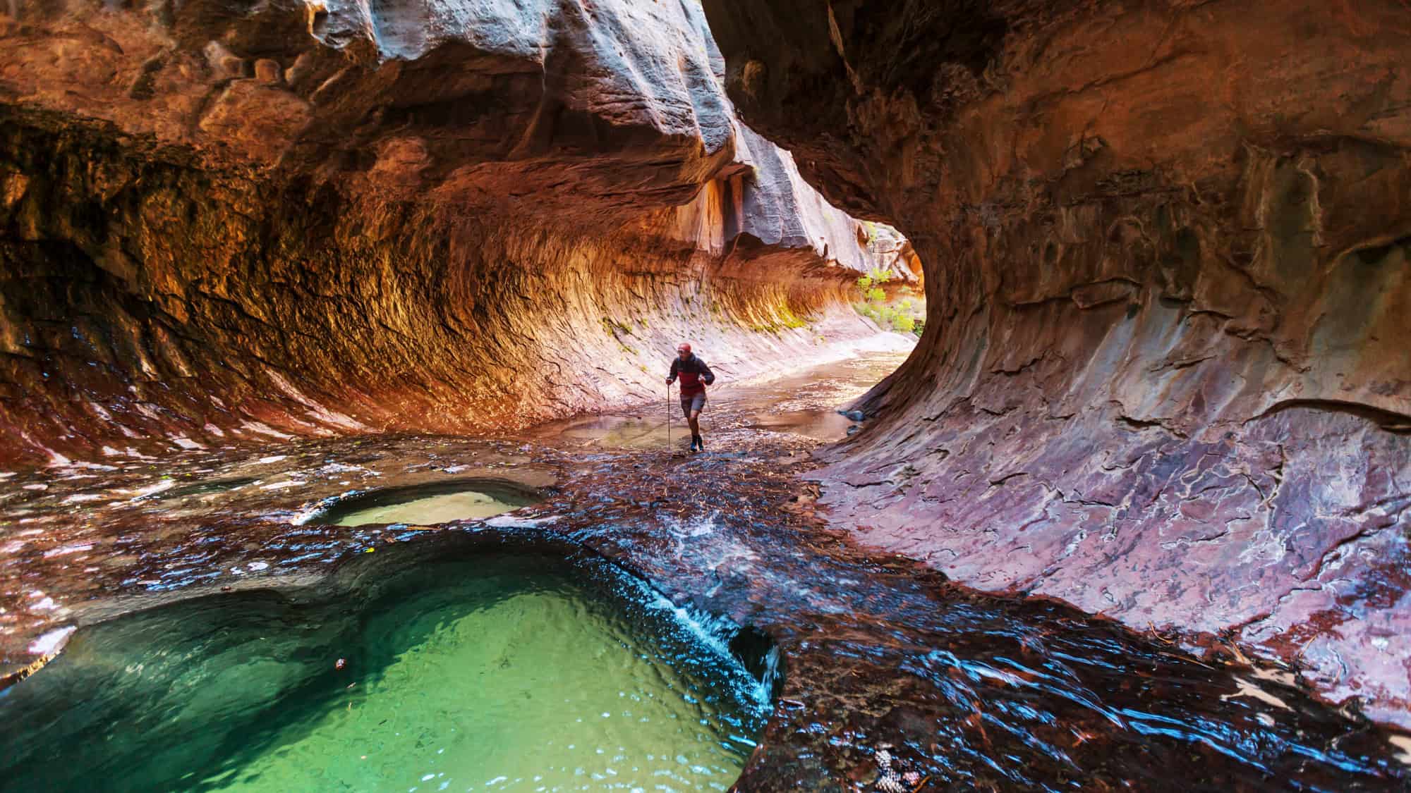
The Subway is a unique, tubular formation in the Left Fork of North Creek within Zion National Park. It is named for its resemblance to a subway tunnel, carved out by the relentless force of water.
Visiting this geological wonder is a serious endeavor that requires a wilderness permit drawn via a seasonal and daily lottery. The park limits access to just 80 people per day to protect the fragile environment.
There are two ways to explore the Subway: a technical top-down route that involves rappelling and swimming in cold water, or a non-technical bottom-up hike that is physically demanding but requires no special climbing gear.
The bottom-up route that most travelers can complete is roughly 9 miles round-trip and involves extensive scrambling over boulders and walking directly in the creek. You will pass dinosaur tracks preserved in the mudstone layers along the way, a reminder of the ancient history of this region.
The final destination features emerald-colored pools and the famous rounded tunnel walls.
Because the hike involves navigating slippery surfaces and cold water, proper footwear and potentially a wetsuit are recommended depending on the season. And flash flood danger is a real concern here, so you must always check the weather forecast and consult with rangers at the visitor center before heading out.
Carlsbad Caverns National Park, New Mexico

Beneath the Chihuahuan Desert lies Carlsbad Caverns National Park, home to more than 119 caves formed when sulfuric acid dissolved the surrounding limestone.
The main attraction is the Big Room, a massive underground chamber that covers 8.2 acres and is 4,000 feet long. It is the largest single cave chamber in North America by volume, filled with towering stalagmites, delicate stalactites, and draperies of flowstone.
You can access the cavern by hiking down the steep Natural Entrance trail, which drops 750 feet into the earth, or by taking an elevator directly from the visitor center to the Big Room.
The temperature inside the cave remains a constant 56°F year-round, so bringing a light jacket is necessary even if it is sweltering outside.
The park offers ranger-guided tours to other caves, such as King’s Palace and Slaughter Canyon Cave, for those interested in exploring beyond the self-guided trails. These tours often require reservations well in advance and involve crawling through narrow passages.
Aside from the geology, the park is famous for its colony of Brazilian free-tailed bats. From late spring through October, hundreds of thousands of bats exit the cave at dusk to feed on insects, creating a spectacular natural show known as the Bat Flight.
Mammoth Cave National Park, Kentucky

Mammoth Cave National Park preserves the longest known cave system in the world. Explorers have mapped more than 420 miles of passageways, and new discoveries are still being made.
This unique wonder is located in the Green River valley of central Kentucky and offers a variety of tours ranging from easy walks to intense “wild cave” crawls.
The cave itself formed in thick layers of limestone capped by a layer of sandstone, which protected the cave from collapsing while water hollowed it out from below. And the history of the cave is vast, with evidence of Native American exploration dating back thousands of years.
The interior temperature of Mammoth Cave stays around 54°F, providing a cool retreat during humid Kentucky summers. Tours showcase vast chambers like the Rotunda and intricate formations like Frozen Niagara.
Because of the white-nose syndrome affecting bat populations across North America, you will be required to walk across bio-security mats after your tour to prevent the spread of the fungus to other areas.
The park above ground is also worth exploring, with over 80 miles of hiking trails through lush forests. The contrast between the vibrant green surface world and the silent, dark labyrinth below makes this a fascinating destination.
Via Ferrata Lipella, Italy

For a different kind of geological adventure, the Via Ferrata Lipella in the Italian Dolomites offers a historic and scenic climbing route.
A via ferrata, or “iron path,” is a protected climbing route equipped with steel cables, rungs, and ladders, allowing hikers to access difficult peaks without technical rock climbing skills. And this specific route climbs the massive west face of Tofana di Rozes, a peak that reaches 10,581 feet in elevation.
The trail is long and demanding, often taking 6 to 8 hours to complete, so you need to be in good physical condition and acclimated to the altitude.
The route begins by passing through the Castelletto tunnels, a system of galleries excavated by Italian soldiers during World War I. You will need a headlamp to navigate these dark, spiraling tunnels before emerging onto the cliff face.
As you ascend the limestone rock, the views of the surrounding Dolomites are breathtaking.
But the route gains over 2,600 feet of vertical elevation, exposing you to sheer drops and dramatic vistas. So you must have proper gear, including a helmet, harness, and via ferrata lanyard, to safely attempt this climb.
Torres Del Paine National Park, Chile

Torres del Paine National Park in southern Chilean Patagonia is dominated by the Paine Massif, an eastern spur of the Andes Mountains. The park encompasses a diverse range of environments, including ancient forests, glaciers, lakes, and rivers, making it a premier destination for trekkers.
The park was established in 1959 and is a UNESCO Biosphere Reserve, recognized for its ecological importance.
The centerpiece of the park is the three granite towers known as the Torres del Paine, which rise up to 9,350 feet into the sky. These jagged peaks were formed by intrusive igneous rock that was later eroded by glacial ice, leaving behind the hard granite spires.
The famous “W Trek” is a multi-day hiking route that takes you past the park’s highlights, including the towers, the French Valley, and Grey Glacier.
The Blue Towers, as they are sometimes called, look particularly stunning at sunrise when the rock glows red and orange. You can spot guanacos, Andean condors, and potentially pumas if you are lucky and observant along the route.
Just be aware that the weather in Patagonia is notoriously unpredictable, often cycling through four seasons in a single day, with strong winds that can knock you off balance.
Wulingyuan, China
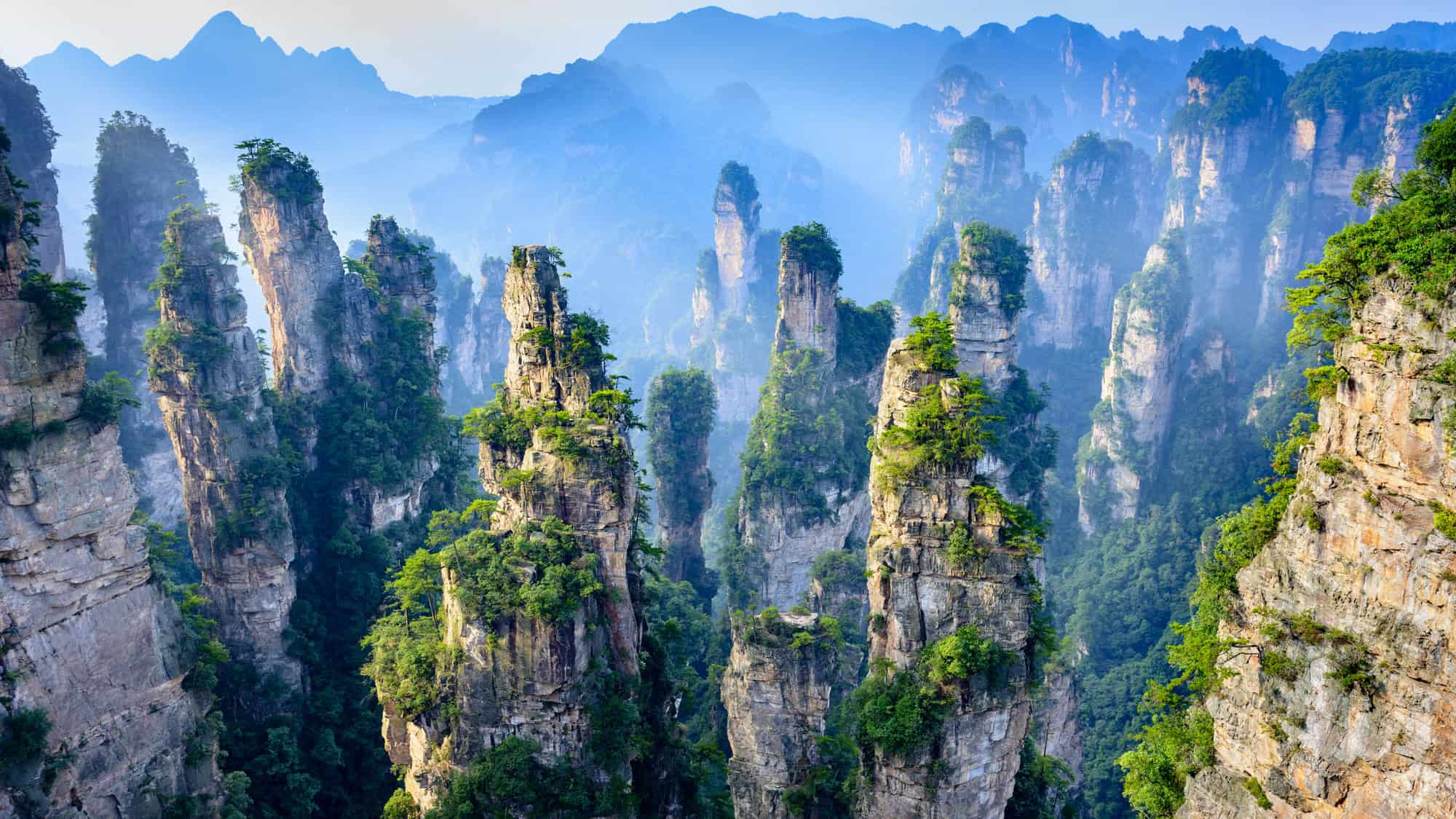
Located in the Hunan Province of China, the Wulingyuan Scenic and Historic Interest Area is famous for its quartzite sandstone pillars. There are more than 3,000 of these narrow peaks, many of which are over 650 feet tall, with the highest reaching over 1,300 feet.
Vegetation clings to the tops and sides of the spires, adding splashes of green to the gray and red rock. And the landscape is often shrouded in mist, giving the stone columns a floating appearance that inspired the Hallelujah Mountains in the movie Avatar.
You can explore the site using a series of cable cars, the Bailong Elevator (built into the side of a cliff), and extensive walking paths.
The area is also home to a number of endangered plant and animal species, including the Chinese giant salamander.
While the site can be busy with domestic tourists, the sheer scale of the park allows you to find quieter spots to admire the vertical landscape.
Goreme National Park, Turkey
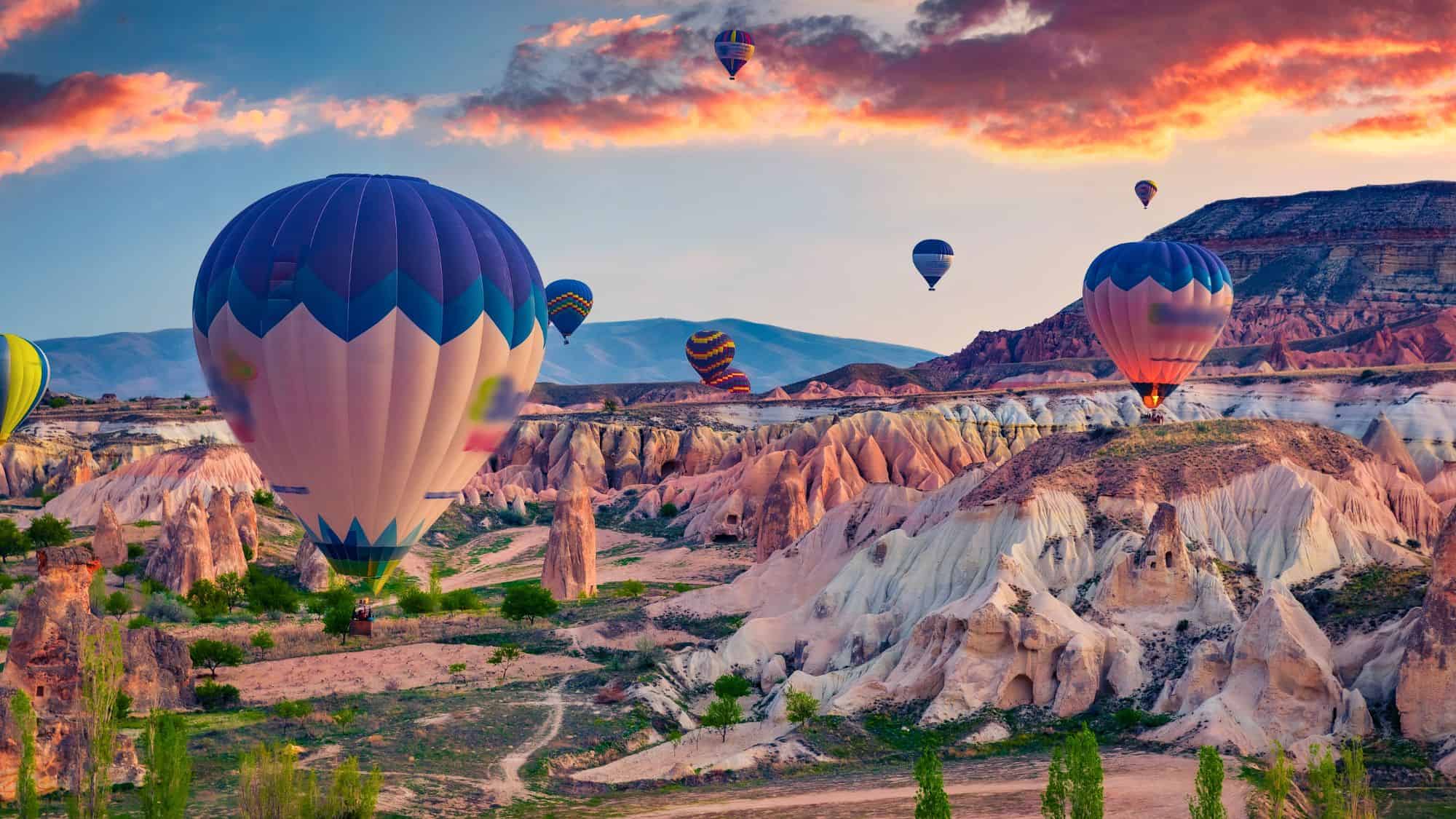
Goreme National Park in the Cappadocia region of Turkey is renowned for its “fairy chimneys,” tall, cone-shaped rock formations clustered in Monks Valley and elsewhere.
These structures were created by geological activity involving ancient volcanic eruptions that covered the region in thick ash, which solidified into a soft rock called tuff. Over millions of years, wind and water eroded the softer tuff, leaving behind harder basalt caps that sit atop the pillars, protecting them from further erosion.
This process resulted in the surreal, honeycomb landscape that defines the region today.
Starting as early as the 4th century, people realized the soft rock was easy to carve and began excavating homes, churches, and entire underground cities within the stone.
One of the most popular ways to see the landscape is by hot air balloon at sunrise, when hundreds of balloons float over the valleys. And walking through the Goreme Open Air Museum allows you to see incredible Byzantine frescoes preserved inside the rock-cut churches, merging art history with geological wonder.
Like Our Content? Follow Us on MSN (or click the Follow Button above) for more from Discover Parks & Wildlife.