Discover Parks & Wildlife contains affiliate links and is a member of the Amazon Services LLC Associates Program. If you make a purchase using one of the Amazon links, we may receive compensation at no extra cost to you. We may also use select AI tools to support our creative process, but all content is reviewed, refined, and finalized by our human team. See our disclosure policy and our AI use policy for more information.
Chasing Wisconsin’s Rare Ice Cathedrals At Apostle Islands
Winter sharpens the southern edge of Lake Superior until it feels ancient and new at the same time. Sandstone cliffs glow red in the low sun. Spray turns to glass. Trails run quiet, and the cold clears the air so far you can read colors you do not see in July.
You come for a rumor that the shoreline grows rooms of ice, tall columns and draped curtains, a frozen echo of water’s steady hand. The story has weight because this lake is moody and huge. It has a way of deciding who gets a glimpse.
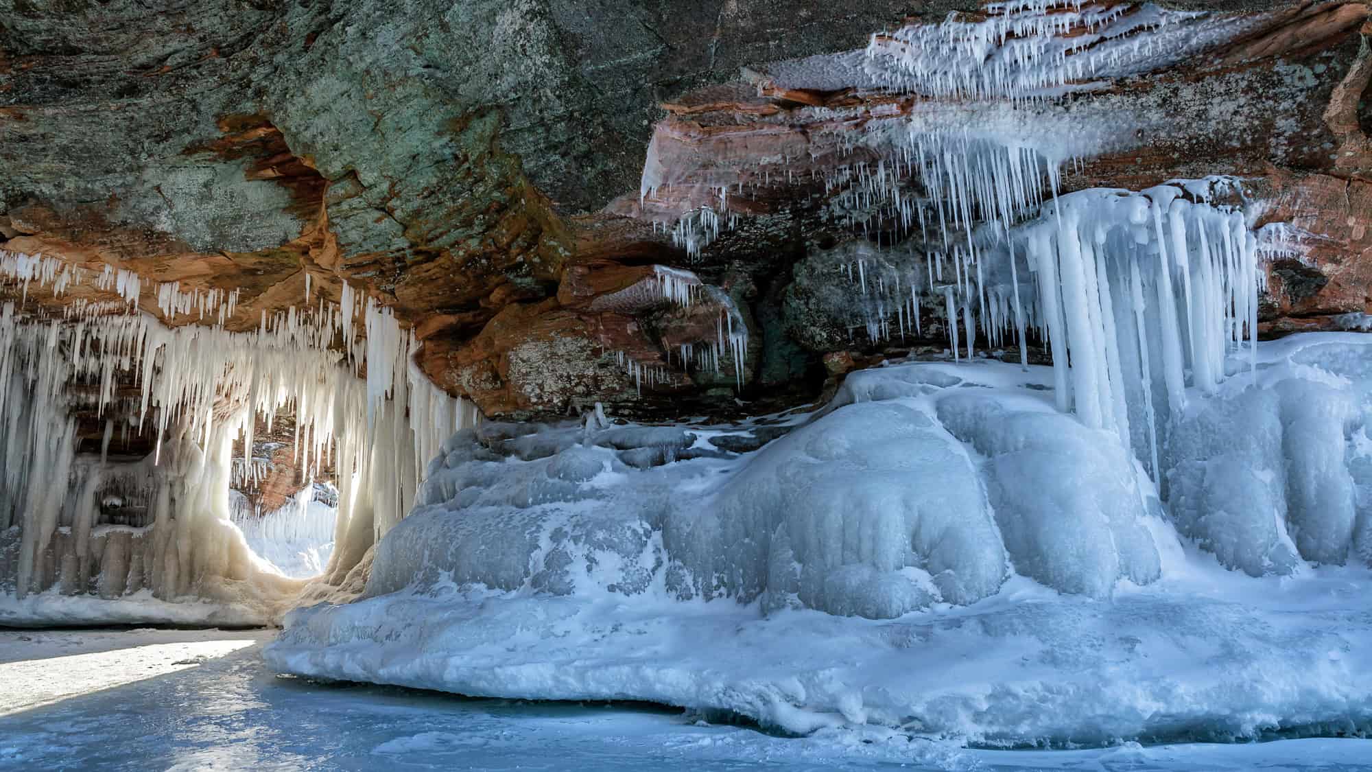
Then the wind drops, the mercury sinks, and everything shifts. The lake hardens. Icicles thicken by day and night. Doors appear in the cliffs, mouths rimmed with chandeliers. Voices travel in soft loops. Footsteps crunch and ring.
But there is no guarantee, only a chance that winter gives in select years to see this magical occurrence. If it happens, you go carefully and you go prepared. After all, this lake rewards patience, and it punishes shortcuts.
What Turns Sea Caves Into Ice Cathedrals
The Apostle Islands line the Bayfield Peninsula with a rim of brownstone cliffs. Waves carve recesses and arches (the sea caves) through steady work that runs all year. In deep winter, spray freezes on contact while groundwater seeps through the rock and builds columns from floor to ceiling.

Each cold night adds a thin coat. Over time, smooth glaze grows into organ pipes, ribbed curtains, and glassy fins that catch the light.
The most famous stretch sits along the mainland near Meyers Beach, where open-water exposure creates bigger waves and more dramatic formations.
The formula sounds simple. Long cold. Minimal wind. Time. In practice, it is difficult. A short warm spell can undo weeks of progress. A hard gale can break the forming shelf that protects shoreline ice.
That is why photos from one week may show rooms of crystal, and the next week reveal open water. The lake builds. The lake erases. You have to plan for both.
Why Access Is So Rare, And What It Means For You
Walking to the ice cathedrals happens only when a stable shoreline shelf forms and holds. Some winters never produce it. Others offer a brief window measured in days. A single night of strong wind can shatter the shelf and make the route unsafe by morning.
Conditions change fast, so you should treat this as a special event that comes without a promise.
The park announces access only when the surface meets strict safety checks. Rangers monitor ice quality, not just air temperature, because pressure cracks, currents, and wave action matter. Your job is to verify, prepare, and stay flexible.
Start by watching for official updates in late January through February, the core window when the cold tends to be strongest. And keep your plans soft enough to shift by the day.

What It Feels Like When They Open
You step onto a white plain, then the cliffs rise in bands of cinnamon and rust. At the base, arches frame doorways rimmed with long crystal teeth. Inside, drip lines have frozen into ribs. Some are clear, some cloudy, some stained by tea-colored minerals that warm the ice with amber tones.
Thick sheets turn the light blue. And the floor can be polished and slick or dusted with windblown snow. Sounds carry in soft loops, so even whispers hang in the air.
Every chamber shifts your sense of scale. One room may hold delicate straws that chime in a breeze. The next may build scallops and long organ pipes that reach your shoulders.
You need to move slowly and read the surfaces. Fresh cracks and taped zones mean stop. Roof ice can fall without warning, so stay alert when you hear a drip or a pop.
It feels both fragile and strong.
How To Visit When Conditions Allow
So you’ve decided you want to attempt a visit? Here is what you need to know.
Confirming Access And Timing
You can check three official sources on the morning you plan to go.
First, the park’s Ice Caves status page, which announces if access is open or closed. Second, the recorded Ice Line at 715-779-3398, extension 3, for on-the-ground updates from rangers. Third, the Apostle Islands National Lakeshore Facebook page, where staff post current conditions and alerts.
If none of these show an “open” notice, the caves are not open that day.
Keep your target window flexible, because the best chance is most common in late January through February when nights stay well below freezing. Watch for a trend, not a single night with freezing temps. A chain of cold days helps the ice lock in.
Plan to arrive early, before crowds compete for parking, and to give yourself daylight for a safe return. Then set a hard turnaround time and stick to it.
Consider having a backup plan or time in your schedule to wait a few days. Waiting for a better call is smarter than forcing one when the lake is not ready. Patience keeps you safe and usually improves your experience.

Parking, Fees, And Facilities
Parking sits at the Meyers Beach lot on Highway 13. On open days, spaces fill fast, so aim for an early arrival. There is a fee to park, so bring cash and credit so you are covered either way.
Keep valuables out of sight and lock your vehicle before heading down. If the lot is full, do not park on road shoulders or in signed no-parking areas. Law enforcement patrols during high visitation, and unsafe parking can lead to tickets or towing.
After fresh snow, check for plow berms that can trap low-clearance vehicles. Give yourself time at the end of the day to exit before the lot turns slick.
Vault toilets are usually available, but there is no potable water at the lot, so bring what you need.
Planning Your Route From Meyers Beach
From the Meyers Beach access point, step onto the frozen shoreline and head northeast along the base of the cliffs. The distance depends on how many features you explore, but a common out-and-back ranges from a few miles to more than five.
Surfaces vary, from packed snow to glare ice to broken crust. Expect a slow pace and pauses to assess surface changes. Microspikes help you stay balanced on polished sections.
Keep clear of taped zones or fresh fractures. Take your time near entrances, where hidden wave action can thin the floor. If the shelf turns rough or wet, step inland toward firmer ice and reassess.
Mark simple landmarks as you go, such as a distinct arch or a wide orange band in the rock. Flat light can make the return feel confusing. Visual cues help you stay oriented without wasting time or energy.

What To Wear And Pack
Dress for real cold and quick changes. Start with a moisture-wicking base layer. Add an insulating mid-layer such as fleece or a puffy. Finish with a windproof outer layer that blocks spray. On your legs, pair a warm base with soft shell pants that shed snow.
Hands stay happy with liner gloves that are insulated and have a waterproof outside. Bring a warm hat and a neck gaiter that can shield your face when the wind kicks up. Wear insulated winter boots with solid ankle support, then add microspikes for traction.
Pack high-calorie snacks, a thermos with a hot drink, and at least one water bottle carried upside down so the lid does not freeze. A headlamp, small first aid kit, whistle, and paper map round out safety.
Keep your phone close to your body for warmth to protect battery life in the cold.
Safety, Etiquette, And Rules
Treat the lake as moving terrain. Scan every surface before you place weight. Avoid areas that sound hollow, show slush, or carry running water noises. Stay back from cliff faces when you hear active dripping, because roof ice can break without warning.
Follow ranger guidance and posted closures. Do not cross tape or cones.
Keep your group tight and talk before stopping so no one drifts onto weaker ice while adjusting gear. Yield narrow passages and give others space inside chambers.
Voices carry, so keep noise low to preserve the hush that makes this place special. Pack out every wrapper and avoid leaning on delicate curtains or striking icicles. Alcohol dulls judgment in the cold, so save that for later.
Policies can change annually, so make sure to look up details right before you visit. And if someone falls or is injured, call for help, shield them from the wind, and keep them warm while you wait.
Lodging And Gear Rentals
Base yourself in Bayfield for the shortest drive to Meyers Beach, or look at nearby Washburn and Cornucopia for quieter stays. Winter hours can be limited, so reserve rooms before you travel.
For gear, swing by local outfitters in Bayfield, where you can rent snowshoes, cross-country skis, and fat bikes for alternate plans while you wait to see if the ice caves will be a go. You will also find traction aids, warm hats, and hand warmers for sale, which help if you arrive under-equipped.
🛏 Fancy Option: Queen’s View Bed And Breakfast
🛏 Low/Mid Option: Chequamegon Lake Superior Lodge
When The Lake Says No
Plan on the lake saying no. That is the honest baseline. From 2000 through 2023, the mainland ice caves have been open to walkers only about 2 percent of days, and the last long opening was a brief nine days in 2015.
That means most trips will not line up with safe ice, even during deep cold. So it is important to treat a walk on the shelf as a bonus, not the core plan for your winter trip.
Keep your lodging, meals, and activities aimed at a great winter vacation, then be ready to pivot fast if the park announces an opening.
Fun Alternatives
Start with the Lakeshore Trail from the Meyers Beach lot for high cliff overlooks above the caves. The first big views arrive after roughly 1.8 to 2 miles, with more lookouts farther along.
Add time at Mt. Ashwabay, about 7 miles south of Bayfield, for skiing, snowshoeing, and fat biking when trails are groomed. Rentals are available on site during the season, which makes a last-minute plan easy if you arrive without gear.
If the bay freezes hard, watch local reports for the seasonal ice road or windsled connection between Bayfield and Madeline Island. These options open and close as conditions shift, so confirm status before you go. If service is running, you can reach La Pointe and explore Big Bay State Park’s snowy shores, then return to town for a hot meal.
Round things out in Bayfield and nearby towns. Book a sauna, browse small shops, and warm up with chowder or pie.
At the end of the day, come prepared with what you need on the off-chance you get to see the ice caves. But even without the green light, there is plenty of fun to be had in the winter around Lake Superior.
Like Our Content? Follow Us on MSN (or click the Follow Button above) for more from Discover Parks & Wildlife.