Discover Parks & Wildlife contains affiliate links and is a member of the Amazon Services LLC Associates Program. If you make a purchase using one of the Amazon links, we may receive compensation at no extra cost to you. We may also use select AI tools to support our creative process, but all content is reviewed, refined, and finalized by our human team. See our disclosure policy and our AI use policy for more information.
These 13 Cliffs Are the Reason “Edge-of-Your-Seat” Views Exist
There is a unique sensation that surfaces when you find yourself standing near the edge of a great height. It is a mix of raw fear and profound wonder that draws your gaze toward the horizon, even as your instincts urge you to step back.
We are drawn to these high places, not only for the sweeping views but also for the sense of scale they offer. Perched thousands of feet above a valley floor or a distant coastline, the world below appears surprisingly small and orderly.
The air often feels crisper and quieter, and the sheer magnitude of the landscape serves as a powerful reminder of our place within a much larger story.
Reaching these vantage points frequently demands significant effort, from long hikes over difficult ground to drives along remote, unpaved roads. The reward, however, is an experience that goes beyond what a photograph can convey.
The following dramatic drops offer a test of courage and a perspective that lingers long after you have returned to solid ground. They represent some of the most striking vertical landscapes our planet has to offer.
Cliffs Of Moher – County Clare, Ireland

The Cliffs of Moher are easily one of the most recognizable landscapes in Ireland.
Stretching for about five miles along the Atlantic coast of County Clare, these shale and sandstone bluffs rise to an impressive 702 feet at their highest point near O’Brien’s Tower. And the sheer verticality of the rock face is startling when you first approach the edge.
On a clear day, you can look out across the water to see the Aran Islands, the Maumturks, and the Twelve Pins mountain ranges in Connemara.
Thousands of seabirds, including puffins and guillemots, nest in the stratified ledges, swirling around in the updrafts below you.
Visiting here requires some caution as the weather can turn quickly. Mist and rain often roll in off the Atlantic, obscuring the view and making the cliffside paths slippery. The wind can be fierce enough to knock you off balance if you are not careful.
While there are paved walkways and safety walls near the main visitor center, the trails extend north and south where the barriers disappear.
You can walk towards Hag’s Head to the south for a more rugged experience, where the cliffs seem to crumble directly into the churning ocean below.
Preikestolen (Pulpit Rock) – Norway

Rising 1,982 feet above the Lysefjord in Norway, Preikestolen is famous for its distinctively flat, square top. The plateau measures roughly 82 by 82 feet and looks as if it were carved by a giant knife.
Standing on this granite block offers an unobstructed view of the fjord winding through the landscape below.
The hike to get here is a moderate, four-to-five-hour round-trip that covers about five miles. You will navigate through varied terrain, including marshlands, forests, and stone staircases built by Sherpas from Nepal to make the ascent more accessible.
Once you reach the top, there are no fences or guardrails waiting for you. The drop is completely vertical and immediate. So many visitors choose to crawl on their stomachs to peek over the rim rather than standing near the precipice.
The view down to the water is dizzying, and the boats cruising the fjord look like tiny toys.
Because it is such a popular destination, the plateau can get crowded during the summer months. So use extra caution with large crowds and stand back from the ledges. Also, starting your hike early in the morning can help you beat the rush and enjoy a few moments of quiet.
Toroweap Overlook – Grand Canyon National Park, Arizona

Toroweap Overlook offers a perspective of the Grand Canyon that few visitors ever see. Located on the remote North Rim in Arizona, this viewpoint sits 3,000 feet vertically above the Colorado River.
Unlike the popular South Rim viewpoints, where the river is miles away, at Toroweap, the canyon walls drop straight down to the water. You can even hear the roar of the lava falls rapids echoing up from the depths on quiet days.
The sheer drop is terrifyingly abrupt, offering no gradual slope to ease your mind.
Getting here is a challenge that filters out casual tourists. You must drive roughly 60 miles on unpaved roads that can be impassable after rain. There is no water, gas, or food available, so you have to be completely self-sufficient.
But the lack of infrastructure means you often have this massive landscape entirely to yourself.
The geology here is distinct, with cinder cones and old lava flows adding black basalt accents to the classic red sandstone layers. It is a place of stark beauty and silence. And standing on the sandstone ledges without a single handrail between you and the river is a humbling reminder of the canyon’s true depth and scale.
El Capitan – Yosemite National Park, California

El Capitan in Yosemite National Park is a granite monolith that demands respect. Rising more than 3,000 feet from the floor of Yosemite Valley, it is one of the world’s favorite challenges for rock climbers.
You can also experience the height from the top if you are willing to hike. The trail is long and strenuous, often taking a full day to complete, but it allows you to stand on the brow of the beast.
Looking down from the summit gives you a bird’s-eye view of the Merced River and the pine forests that look like moss from that height. The granite is solid and unforgiving, polished by ancient glaciers.
Be aware that weather patterns in the valley can change rapidly, and clouds often snag on the summit of El Capitan. Watching the mists swirl around the sheer granite face adds a layer of mystery to this imposing geological giant, but it can be dangerous when you are near the edge.
For those who prefer to keep their feet on flat ground, the view from the valley floor looking up is overwhelming. The face of the rock is so vertical and smooth that it is hard to grasp the scale until you spot a tiny speck of color that turns out to be a climber halfway up the wall.
Kalaupapa Cliffs – Moloka’i Island, Hawaii

The sea cliffs on the north shore of Moloka’i in Hawaii are the highest in the world. They rise dramatically from the Pacific Ocean, reaching heights of over 3,000 feet.
These emerald-green walls are incredibly steep and are cut with deep grooves where waterfalls tumble directly into the sea. And the isolation of this coastline is profound.
The sheer verticality made the Kalaupapa Peninsula at the base of the cliffs a natural prison, which is why it was used as a settlement for people suffering from Hansen’s disease, also known as leprosy.
Accessing views of these cliffs is not simple. You cannot drive to the edge and look over in most places. The best way to see the full scale of the walls is from the air or by boat, though rough seas can make the boat trip challenging.
There is a trail that descends the cliff face to the peninsula below, comprising 26 switchbacks over roughly three miles. It is a steep and humid trek that requires a permit to enter the historical park at the bottom.
Bunda Cliffs – Australia

The Bunda Cliffs define the southern edge of Australia, where the Nullarbor Plain meets the Great Australian Bight. These limestone cliffs stretch for over 60 miles and stand between 200 and 400 feet high.
The rock is a stark white and gray that glows brilliantly under the harsh Australian sun. But what makes this view unique is the sheer length of the uniform curtain of rock.
Looking east or west, the cliff line seems to go on forever, forming a perfect barrier against the Southern Ocean.
The landscape inland is flat, arid, and seemingly endless, making the sudden drop into the ocean even more shocking. And the wind here travels thousands of miles across the ocean before hitting land, so be prepared for strong gusts that carry the scent of salt and seaweed up over the limestone edge.
This location is one of the best places in the world for land-based whale watching.
Between May and October, southern right whales migrate to these waters to calve. You can stand on the designated viewing platforms at the Head of Bight and look down to see mothers and calves swimming in the clear blue water below.
White Cliffs Of Dover – Dover, England

The White Cliffs of Dover are an iconic symbol of the English coastline. Facing the Strait of Dover and France, these chalk cliffs reach heights of up to 350 feet. The dazzling white color comes from the microscopic skeletal remains of plankton that accumulated over millions of years.
On a clear day, you can see across the channel to the French coast, which is only about 20 miles away. And the view is steeped in history, serving as a defensive barrier and a welcoming sight for returning travelers for centuries.
Walking along the cliff-top paths offers spectacular views of the busy English Channel below. Ferries shuffle back and forth between Dover and Calais, looking small against the vast expanse of water.
The grassy paths are lined with wildflowers in the spring and summer, providing a soft contrast to the stark white chalk. Erosion is a constant process here, so it is vital to stay on marked trails and away from the fragile edges. The chalk is soft and can crumble without warning.
The juxtaposition of the pastoral green fields ending abruptly in a sheer white drop to the sea is a uniquely British landscape that remains starkly beautiful.
Na Pali Coast – Kauai, Hawaii

Kauai’s Na Pali Coast is a rugged stretch of shoreline that defies easy access. The cliffs here rise as much as 4,000 feet above the Pacific Ocean.
They are folded into sharp, velvet-green ridges and deep, narrow valleys that look like the pleats of a skirt. It might look familiar because this landscape is famous for its appearance in Jurassic Park, and it truly feels like a lost world.
Waterfalls cascade thousands of feet from the cloud-shrouded peaks directly into the ocean or onto secluded beaches. And the energy of the ocean crashing against the base of these massive walls creates a constant, thundering soundtrack to the visual spectacle.
The Kalalau Trail is the only land access to this coast, and it is a grueling 11-mile trek that traverses narrow ledges with steep drop-offs. It is widely considered one of the most dangerous hikes in the U.S. due to crumbling rocks and slippery mud.
Most visitors opt to see the cliffs from a helicopter or a catamaran to appreciate the full scale without the intense physical risk.
Trolltunga – Norway

Trolltunga, or the Troll’s Tongue, is one of the most photographed rock formations in Norway. It is a thin sliver of rock that juts out horizontally from the cliff, hovering about 2,300 feet above Lake Ringedalsvatnet.
The view from the tip of the tongue is surreal, with the dark blue lake winding through the mountains far below. It creates an illusion of floating in mid-air that draws hikers from all over the world.
Reaching this spot requires a serious commitment. The hike is a demanding 17-mile round trip that takes most people 10 to 12 hours to complete.
The weather in the mountains is unpredictable, and snow can linger on the trail well into the summer. There are also no safety rails on the rock itself, so stepping out onto the tip requires a steady nerve.
But the vastness of the surrounding landscape makes you feel incredibly small and is something you will remember forever. And when the fog rolls in, the drop below disappears into a white void, making the experience even more eerie.
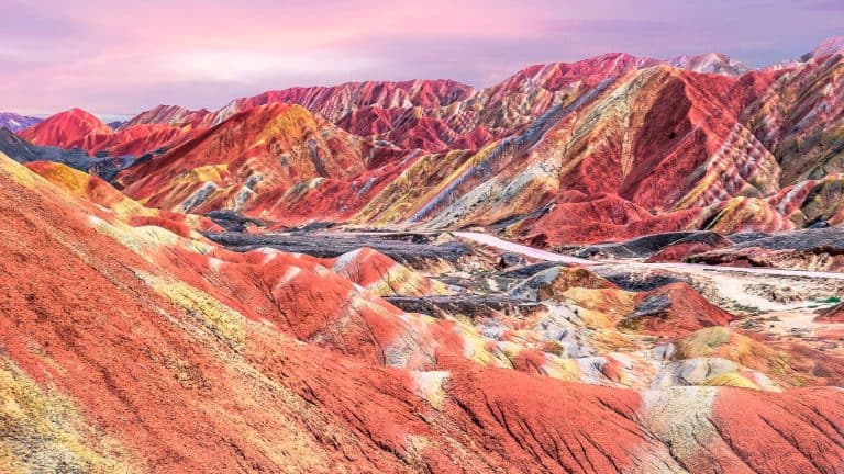
Tiger Leaping Gorge – China

Tiger Leaping Gorge in China is one of the deepest and most dramatic river canyons on the planet. The Jinsha River, a primary tributary of the Yangtze, rushes furiously between the Jade Dragon Snow Mountain and the Haba Snow Mountain.
The name comes from a legend that a tiger once jumped across the river at its narrowest point (about 82 feet wide) to escape a hunter.
The vertical distance from the river to the mountain peaks is approximately 12,430 feet. That means the canyon walls are steep and imposing, creating a narrow, shadowed passage for the turbulent water.
Hiking the High Trail gives you a terrifyingly close look at the steepness of the gorge. The path is carved into the side of the mountain and is often narrow and rocky.
Looking down, you can see the white-water rapids churning with incredible power. The sound of the roaring water is constant and deafening. It creates a sensory experience that is as intense as the visual drop.
Knife-Edge Bridge – Victoria Falls, Zambia

Knife-Edge Bridge offers the premier vantage point for viewing the Main Falls and the Eastern Cataract of Victoria Falls.
Located on the Zambian side, this footbridge connects the mainland to a basalt island that juts out in front of the falling water. The bridge itself is narrow and suspended over a deep gorge, roughly 300 feet above the rocks below.
During high water season, the spray from the falls is so intense that it feels like a heavy rainstorm.
Walking across the bridge is a visceral experience. You are surrounded by the thunderous noise of millions of liters of water crashing down every minute. The air is thick with mist, which often creates vivid rainbows that arc across the gorge.
You will get soaked to the skin within seconds, making it hard to keep your eyes open to take in the view. And the sheer power of the Zambezi River dropping off the edge of the plateau is terrifyingly close.
It is a chaotic, wet, and exhilarating place to stand, offering a front-row seat to one of the world’s largest curtains of falling water.
Cliff Of Bandiagara – Mali

The Cliff of Bandiagara is a magnificent sandstone escarpment in the Dogon country of Mali. It rises about 1,600 feet above the sandy plains and stretches for nearly 90 miles.
This site is not just a geological wonder but a cultural one. The cliff face is dotted with ancient dwellings, granaries, and sanctuaries carved directly into the rock or built with mud on narrow ledges. These structures were built by the Tellem people and later the Dogon to protect themselves from invaders.
The view from the top of the escarpment looks out over the vast, flat Sahel plains. And the contrast between the vertical rock and the horizontal landscape is striking.
Exploring the area involves walking on rocky paths and climbing rough-hewn ladders to reach the villages that cling to the cliffside.
The color of the rock changes with the sun, shifting from gold to deep red. It is a harsh and dry environment, yet it has supported human habitation for centuries. The dizzying heights of the houses serve as a testament to human ingenuity and the drive for security in a challenging landscape.
El Tajo Gorge – Ronda, Spain

The town of Ronda in southern Spain is split in two by the massive El Tajo Gorge. The Guadalevin River has carved this canyon, which is about 400 feet deep and 220 feet wide. The houses of Ronda are built right to the very edge of the cliff, looking as if they might slide into the abyss at any moment.
The most striking feature is the Puente Nuevo, a towering stone bridge completed in 1793 that connects the old Moorish town with the newer parts of the city.
Standing on the bridge or the viewing balconies that overhang the gorge offers a straight-down view that can make your stomach drop. The stone walls of the canyon are sheer and vertical, dropping down to the riverbed far below.
You can walk down paths into the gorge to look back up at the bridge, which is a marvel of 18th-century engineering. And the whitewashed buildings perched on the cliff top contrast beautifully with the warm, earthy tones of the rock.
It is a rare place where urban life meets a dramatic geological fracture so abruptly.
Like Our Content? Make sure to join our newsletter for all the latest on outdoor adventures (and a FREE STARGAZING GUIDE). Click here to sign up!