Discover Parks & Wildlife contains affiliate links and is a member of the Amazon Services LLC Associates Program. If you make a purchase using one of the Amazon links, we may receive compensation at no extra cost to you. We may also use select AI tools to support our creative process, but all content is reviewed, refined, and finalized by our human team. See our disclosure policy and our AI use policy for more information.
14 Shocking Geological Marvels That Prove Nature Has No Limits
Planet Earth has a way of crafting landscapes that seem to belong in a science fiction movie rather than on our own home soil. From stones that move on their own to mountains that look like chocolate drops, nature often defies our expectations of what is physically possible.
We often think we have seen it all, yet there are corners of the globe where geology behaves in ways that baffle scientists and travelers alike.
These locations challenge our understanding of rock, water, and time, serving as reminders that the world is far more mysterious than we usually give it credit for.
Exploring these sites offers a rare glimpse into the powerful forces that shape our planet. You might find yourself standing on a hexagonal pavement created by cooling lava or gazing at a desert that looks like an endless sea of snow.
The following list highlights some of the most surreal formations found across the globe. Are you ready to be surprised by what the Earth has to offer? Let’s take a look.
The Wave – Arizona
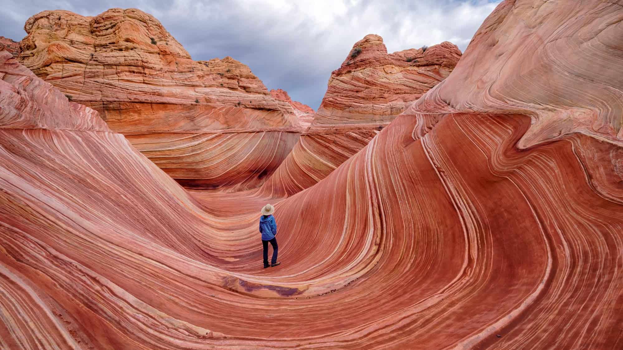
Hidden within Vermilion Cliffs National Monument in Arizona, the Wave creates a visual hallucination of flowing red rock.
This sandstone formation dates back to the Jurassic period and was sculpted by wind and rain into smooth, undulating troughs. The iron oxides in the rock provide a spectrum of colors ranging from deep reds to rusty oranges and pale yellows.
Walking through it feels like traversing a frozen ocean of stone. But the delicate ridges are fragile, and BLM strictly controls access to preserve the site. Getting here is notoriously difficult due to the competitive permit system.
Only 64 people (or 16 groups) are allowed to enter the North Coyote Buttes area each day. A daily lottery awards permits to just 16 people or 4 groups, while an advanced lottery handles the rest.
Winners must navigate a strenuous 6.4-mile round-trip hike without a designated trail, relying on GPS coordinates and visual landmarks. But the exclusivity protects the soft sandstone from being ground to dust by heavy foot traffic.
Those lucky enough to visit find a surreal landscape that changes character with the shifting desert light.
Racetrack Playa Sailing Stones – California

Death Valley National Park holds one of the most puzzling geological phenomena on Earth. On the flat, dry lake bed known as Racetrack Playa, heavy rocks appear to move across the ground on their own, leaving long tracks behind them in the dried mud.
For decades, no one had actually seen them move, leading to wild theories about magnetism or aliens. And the rocks can weigh up to 700 pounds, making their movement across the perfectly flat surface even more baffling.
The mystery was solved in 2014 when researchers finally witnessed the process firsthand. Turns out, it requires a rare combination of conditions.
First, the playa must fill with water deep enough to form floating ice but shallow enough to expose the rocks. At night, thin sheets of “windowpane” ice, about 0.25 inches thick, form on the surface.
When the sun rises and melts the ice, light winds of around 10 miles per hour push these floating ice panels against the rocks. The ice sheets provide just enough force to slide the heavy stones across the slick mud at speeds of up to 20 feet per minute.
Richat Structure – Mauritania

Staring up from the vast sands of the Sahara Desert in Mauritania is a giant bullseye known as the Richat Structure, or the Eye of the Sahara. This prominent circular feature stretches 25 miles across and is so massive that it serves as a landmark for astronauts in orbit.
It stands in total isolation on the Adrar Plateau, a silent watcher looking up at the sky.
Initially, geologists thought it was an impact crater caused by a meteorite striking the Earth. However, the lack of shock-metamorphism in the rock layers ruled out an extraterrestrial collision.
Current scientific consensus is that the Eye is a deeply eroded geologic dome. Over roughly 100 million years, molten rock pushed up towards the surface, creating a dome of rock layers. Wind and water then eroded the top of the dome, peeling away the layers like an onion.
The concentric rings we see today are the result of alternating types of rock eroding at different speeds. The ridges are made of resistant quartzite, while the valleys are softer sedimentary rock.
Striped Icebergs – Antarctica

We typically think of icebergs as monolithic blocks of blinding white, but in the Southern Ocean, you might spot something far more colorful.
Striped icebergs are a rare and beautiful phenomenon found off the coast of Antarctica. These floating sculptures display bands of blue, green, brown, and even yellow.
What do they mean? Well, the stripes tell the story of the iceberg’s formation and the conditions of the water from which it was born.
Blue stripes appear when ice melts and refreezes rapidly, squeezing out the air bubbles that normally scatter light and make ice look white. Green stripes can occur when the seawater freezing onto the iceberg is rich in algae. Brown or yellow lines often indicate that the iceberg picked up sediment from the ground as it scraped its way toward the ocean.
Regardless of color, watching these multi-colored giants drift through the dark waters of the Weddell Sea is a stark contrast to the monochrome landscape usually associated with the polar regions.
Dallol Hydrothermal Field – Ethiopia

The Danakil Depression in Ethiopia is one of the hottest and most inhospitable places on Earth, yet it hosts a landscape of startling beauty. It is the lowest-lying volcano on the planet, sitting roughly 410 feet below sea level.
The Dallol hydrothermal field is a riot of neon colors, with vibrant greens, yellows, and oranges bubbling up from the ground. It looks less like a geological formation and more like a science experiment gone wrong.
The colors come from the oxidation of inorganic iron compounds. Hot magma below the surface heats groundwater, which then rises and dissolves salt, potash, and other minerals.
As the brine reaches the surface and evaporates, it leaves behind crusty salt formations colored by the minerals. The pools are highly acidic and toxic, often releasing hazardous gases.
It is a dangerous beauty, and visiting requires a convoy with armed guards due to the region’s instability. But if you can swing a visit, the sensory overload of heat, smell, and color makes Dallol an unforgettable, if intense, experience.
Shilin Stone Forest – China

In the Yunnan Province of China, trees made of limestone rise from the ground to create the Shilin Stone Forest. Covering an area of roughly 150 square miles, this UNESCO World Heritage Site features towering rock pillars that resemble petrified trees. Some of these formations stand nearly 100 feet tall.
The Stone Forest was formed roughly 270 million years ago. The area was once a shallow sea, and extensive limestone deposits built up over time.
As the sea receded and the tectonic plates shifted, the limestone bed rose up. Wind and rain then spent millions of years eroding the softer rock, carving out the vertical pillars we see today. The shapes are intricate and varied, with some looking like animals, people, or pagodas.
The labyrinthine nature of the site allows you to walk through narrow paths between the stones, creating a sense of being lost in a mineral jungle. And local legends tell stories of forbidden love and people turning to stone, adding a layer of myth to the geology as you explore.
Devils Postpile – California

Devils Postpile National Monument protects a bizarre formation of columnar basalt that looks like a giant pipe organ.
The columns here are incredibly uniform, with most being hexagonal, though you can find some with anywhere from three to seven sides.
They tower up to 60 feet high, creating a sheer wall of dark rock. And the symmetry is so precise that early explorers struggled to believe it wasn’t an artificial structure constructed by human hands.
The formation began roughly 100,000 years ago when a lava vent flowed into the valley. The lava pooled and began to cool. Because the pool was deep, the cooling process was slow and even, allowing the rock to crack in long, regular vertical columns.
Later, glaciers flowed down the valley, shearing off the top of the lava flow and revealing the hexagonal cross-sections on top. This polished top surface looks like a tiled floor, giving you a clear view of the geometric perfection nature can achieve.
Giant’s Causeway – Northern Ireland
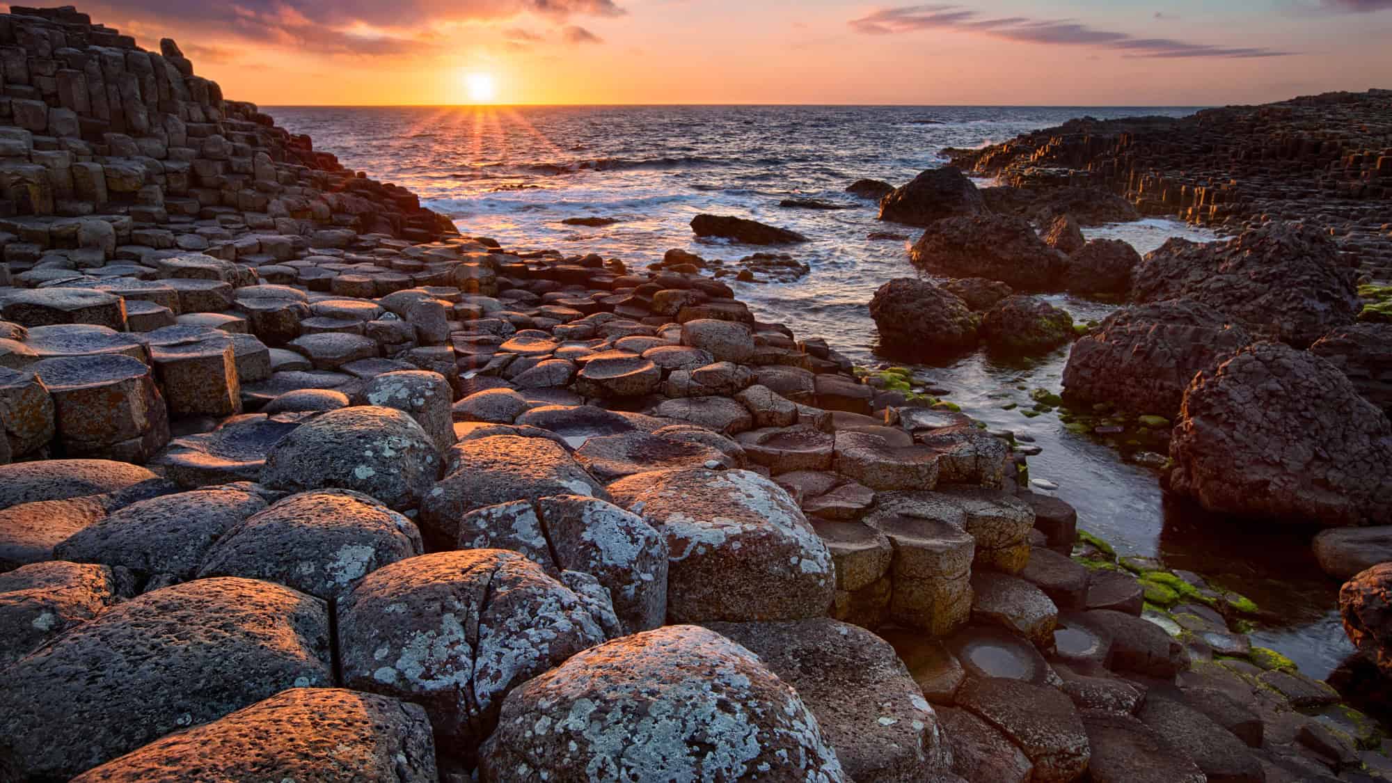
Across the Atlantic in Northern Ireland, a similar but even more famous basalt formation exists at the Giant’s Causeway. Located in County Antrim, this site features about 40,000 interlocking stone columns that step down from the cliff foot and disappear under the sea.
Most of the columns are hexagonal, fitting together perfectly like a puzzle. And the landscape is dramatic, with the dark stone contrasting sharply against the crashing waves of the sea.
Legend says the causeway was built by the giant Finn MacCool to cross the sea and fight a Scottish rival.
Scientists say otherwise. Geologically, it formed 50 to 60 million years ago during intense volcanic activity. Molten basalt intruded through chalk beds, forming an extensive lava plateau. As the lava cooled rapidly, it contracted and cracked. The vertical cracking created the pillar-like structures.
Today, you can walk directly on the stones, hopping from column to column, and see firsthand how the cooling rock fractured into such orderly shapes.
Chocolate Hills – Philippines

In the Bohol province of the Philippines, more than 1,260 cone-shaped hills dot the landscape as far as the eye can see. They are generally symmetrical and vary in height from 100 to 160 feet.
During the rainy season, the grass covering the hills is a vibrant green. However, in the dry season, the vegetation dies off and turns chocolate brown, giving the hills their delicious name. To many, they look like endless rows of chocolate kisses dropped onto the island.
But these hills are actually made of limestone. Millions of years ago, this area was submerged underwater. Coral and sea life remains accumulated, forming thick limestone layers. Tectonic shifts eventually lifted the ground above sea level.
Rainwater, groundwater, and erosion then went to work, dissolving the limestone and carving out the valleys between the mounds. This type of karst topography is common, but the regularity and sheer number of the Chocolate Hills make them a unique oddity.
Ringing Rocks Park – Pennsylvania

Most rocks make a dull thud when you hit them with a hammer, but the boulders in Ringing Rocks Park sing. And this seven-acre field of diabase boulders has puzzled scientists and visitors for years.
When struck, many of the rocks produce a metallic, bell-like tone. The sound is clear and resonant, completely unlike the noise you would expect from a stone.
The field itself is strange because it is devoid of vegetation, even though it is surrounded by a dense forest.
The boulders are igneous rock, likely formed around 200 million years ago. While the exact reason for the ringing is debated, it is thought to be related to the high iron content and the immense internal stress within the rocks.
Not every rock in the field rings, and the “live” rocks often stop ringing if you remove them from the pile, suggesting the contact between stones plays a role.
If you are up the Pennsylvania way, bring a hammer to the park and create your own geological music.
Marble Caves – Chile

Deep in the Patagonia region of Chile, the azure waters of General Carrera Lake have carved out a cathedral of stone. The Marble Caves, or Capilla de Marmol, are a network of caverns, tunnels, and pillars formed in solid marble.
Over the last 6,000 years, the waves have washed against the calcium carbonate cliffs, dissolving the rock and smoothing the surface into intricate shapes.
Be aware that the water level fluctuates throughout the year, changing the appearance and accessibility of the caves. When the water is low, you can take a small boat or kayak deep into the recesses.
The swirling patterns in the marble walls look like oil paintings, and the isolation of the location adds to the feeling of discovering a secret world. Plus, the water here is glacial, giving it a brilliant turquoise hue.
This vibrant blue light reflects off the white and gray marble walls, creating a surreal, glowing atmosphere inside the caves that will have your jaw dropping to the floor.
Yosemite Exfoliation Domes – California

Yosemite Valley is renowned for its massive granite features, but the shape of its domes tells a specific geological story.
Domes like North Dome and Sentinel Dome formed through a process called exfoliation. As erosion removed the heavy layers of rock that once sat on top of the granite, the pressure on the granite was released.
This caused the rock to expand and crack in curved layers parallel to the surface, much like the layers of an onion. Over time, these outer layers peel off and fall away, leaving behind the rounded, dome-like shape.
Glaciers also played a huge role in Yosemite, polishing the granite and steepening the sides of the domes, but the rounded tops are largely due to this pressure release.
Standing on top of these domes offers panoramic views of the Sierra Nevada, and seeing the peeling layers of rock up close gives you a sense of the immense timescales involved in shaping this landscape.
Tsingy De Bemaraha – Madagascar

In Madagascar, Tsingy de Bemaraha National Park presents a landscape that looks completely impenetrable. The word “tsingy” translates roughly to “where one cannot walk barefoot,” and one look at the terrain explains why.
The park is a forest of razor-sharp limestone pinnacles, some rising hundreds of feet into the air. The rocks are jagged and needle-like, creating a fortress of stone that is difficult for humans to traverse but perfect for the local wildlife.
This topography is known as tropical karst. Groundwater infiltrated the great limestone plateaus, dissolving the rock along joints and cracks.
Over millions of years, this created deep fissures and caves. The roof of these caves eventually collapsed, leaving behind the sharp spires that stand today.
Despite the harsh environment, the Tsingy is home to 11 species of lemurs, which leap comfortably between the sharp rocks. It is a stunning example of how life adapts to even the most jagged environments.
White Sands – New Mexico

Rising from the Tularosa Basin in New Mexico is the largest gypsum dunefield on Earth. White Sands National Park covers 275 square miles of glistening white dunes that look exactly like snowdrifts.
But unlike the quartz sand found on most beaches, the sand here is made of gypsum crystals. Gypsum is soft and rarely found in sand form because it dissolves easily in water. However, the basin here has no outlet to the sea, trapping the dissolved gypsum.
When the water evaporates, the gypsum crystallizes and is broken down by the wind into tiny grains. The prevailing winds then push these grains into massive dunes that can reach 60 feet high. And the dunes are constantly moving and shifting, engulfing plants and roads in their path.
Because gypsum does not absorb heat like silica sand, you can walk on the dunes barefoot even in the height of summer without burning your feet.
Like Our Content? Follow Us on MSN (or click the Follow Button above) for more from Discover Parks & Wildlife.