Discover Parks & Wildlife contains affiliate links and is a member of the Amazon Services LLC Associates Program. If you make a purchase using one of the Amazon links, we may receive compensation at no extra cost to you. We may also use select AI tools to support our creative process, but all content is reviewed, refined, and finalized by our human team. See our disclosure policy and our AI use policy for more information.
11 Bizarre Desert Mysteries That Will Leave You Speechless
Deserts are often dismissed as empty wastelands of sand and sun, but these arid landscapes hide some of the most perplexing puzzles on Earth.
Far from being barren voids, deserts are active, shifting environments where the rules of nature seem to bend or break entirely. You might expect endless dunes, but you will also find unexplained geometric patterns etched into the earth, stones carved by invisible hands, and ecosystems that survive against all odds.
Exploring these dry lands offers a glimpse into the raw power of the planet. Somehow, the extreme conditions found here create phenomena that simply do not exist anywhere else.
We often look to the stars for the unknown, yet right here on our own planet, there are landscapes that look and feel completely alien. And preparing for a trip to these destinations requires more than just water and sunscreen. It demands an open mind ready to witness the impossible.
Let’s look at some of the most fascinating desert mysteries just waiting to be explored.
The Unexplained Fairy Circles Of Namib Desert – Namibia

In the arid grasslands of the Namib Desert, a strange phenomenon dots the landscape. Millions of circular patches of bare earth, surrounded by rings of tall grass, stretch across the sandy soil.
These are known as fairy circles. They create a distinct hexagonal pattern that looks almost man-made from the air, yet they are entirely natural.
Most of these circles range between 13 and 33 feet in diameter and are confined to a narrow strip of land where rainfall is scarce, typically around 4 inches per year.
Scientists have debated the cause of these circles for decades without reaching a definitive conclusion. One leading theory suggests that termites are responsible, clearing the vegetation around their nests to capture moisture in the porous soil.
Another theory proposes that the plants themselves organize into this pattern to compete for limited water resources. Regardless of the reason, the circles seem to have a life cycle of their own, appearing and vanishing over decades.
Visiting the NamibRand Nature Reserve offers you the best chance to see these formations up close.
Sculpted Stones Of The White Desert – Egypt
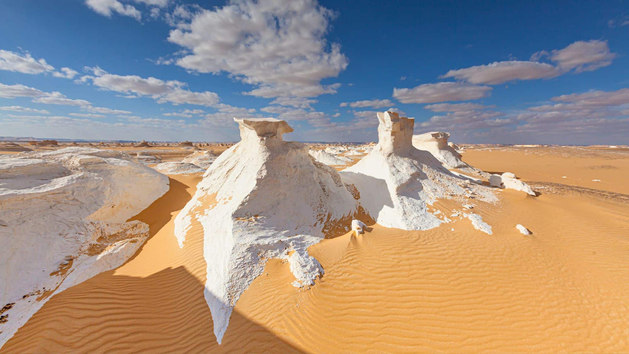
Deep in the Farafra depression of Western Egypt lies a landscape that looks more like a sculpture garden than a typical desert.
White Desert National Park is famous for its massive chalk rock formations, which have been carved into bizarre shapes by centuries of wind and sand. These geological oddities are known as ventifacts.
The most famous among them resemble giant mushrooms, chickens, and craggy peaks, standing in stark white contrast to the yellow desert sands surrounding them.
The process that creates these forms is relentless. Windblown sand acts like sandpaper, slowly eroding the softer layers of the chalk while leaving the harder rock intact. This differential erosion results in top-heavy structures that seem to defy gravity.
Walking among them at sunset provides a ghostly experience as the white rocks reflect the changing colors of the sky, turning from blinding white to pink and orange. You can also camp overnight here to see the shapes under the moonlight, which adds another layer of mystery to this alien terrain.
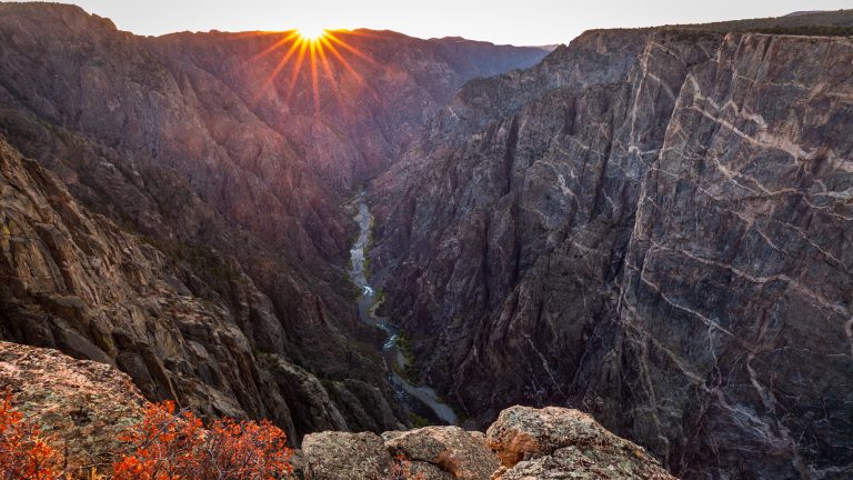
The Furnace Of Death Valley – California

Death Valley National Park in California holds the title for the hottest air temperature ever recorded on Earth. On July 10, 1913, the mercury at Furnace Creek soared to a blistering 134°F.
While some meteorologists have debated the accuracy of that century-old reading, modern temperatures regularly climb above 120°F in the summer months. And this extreme heat creates a dangerous environment that pushes the limits of human survival and transforms the landscape itself.
The heat here is not just a weather statistic. It is a physical force. The ground radiates warmth long after the sun goes down, keeping overnight lows uncomfortably high. This intense thermal energy contributes to the valley’s dynamic weather patterns and atmospheric pressure.
The shimmering heat waves distort the horizon, making distant mountains look like mirages. It is a place where the sun feels heavier than anywhere else, and the air itself seems to have weight.
Visitors are often warned to stay in their vehicles if they break down, as the heat can be fatal within hours. But despite the danger, the severe climate attracts those curious to feel the power of such extremes.
Badwater Basin And The Salt Polygons – California
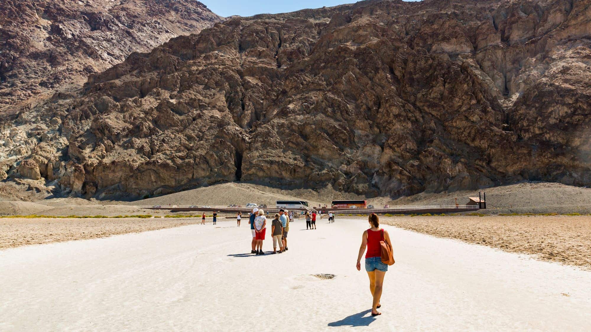
Just miles from the scorching heat of Furnace Creek lies the lowest point in North America. Badwater Basin sits 282 feet below sea level, a surreal expanse of white salt flats covering nearly 200 square miles.
This area was once the site of an ancient inland lake known as Lake Manly, which evaporated tens of thousands of years ago. With no outlet to the ocean, the water left behind concentrated deposits of sodium chloride, calcite, and gypsum.
Today, you can walk out onto a crust that creates a mesmerizing geometric puzzle. Groundwater rising through the salt deposits evaporates and leaves behind ridges that form large polygons. These hexagonal shapes cover the basin floor, creating a textured white carpet that crunches underfoot.
The contrast between the blinding white salt and the dark, towering cliffs of the Black Mountains makes for incredible photography. You can only imagine how rare it is to see snow-capped peaks while standing below sea level in a salt desert.
High Altitude Dryness In Atacama Desert – Chile
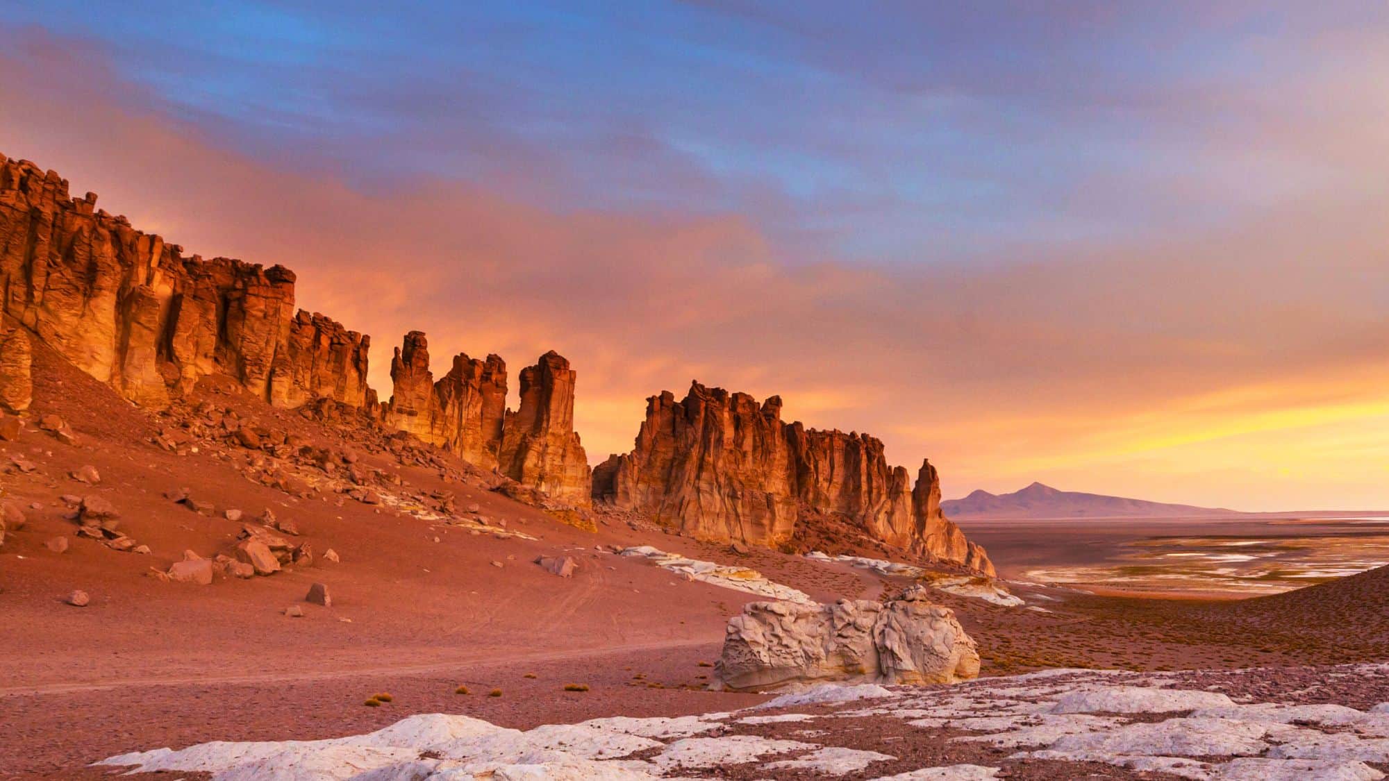
The Atacama Desert in Chile is widely considered the driest non-polar place on the planet. In fact, some weather stations in this region have never recorded rain, while the average annual rainfall is a mere 0.6 inches.
This extreme aridity is caused by the Andes Mountains blocking moisture from the east and the cold Humboldt Current preventing rain from the west. The result is a landscape so barren and Mars-like that NASA uses it to test rovers and instruments destined for the Red Planet.
Beyond the dryness, the high altitude of the Atacama creates its own strange phenomena. The clear, thin air and lack of light pollution make it one of the best places on Earth for stargazing. You can actually see the Milky Way cast a shadow on the ground here.
The desert is also home to high-altitude salt flats and geysers that erupt with boiling water, creating a stark contrast to the freezing morning air.
And if all that wasn’t enough, the silence in the Atacama is profound. There are vast stretches where no plants grow, no animals roam, and the only sound is the wind moving over rocks that have remained unchanged for millions of years.
The Ghost Trees Of Deadvlei – Namibia
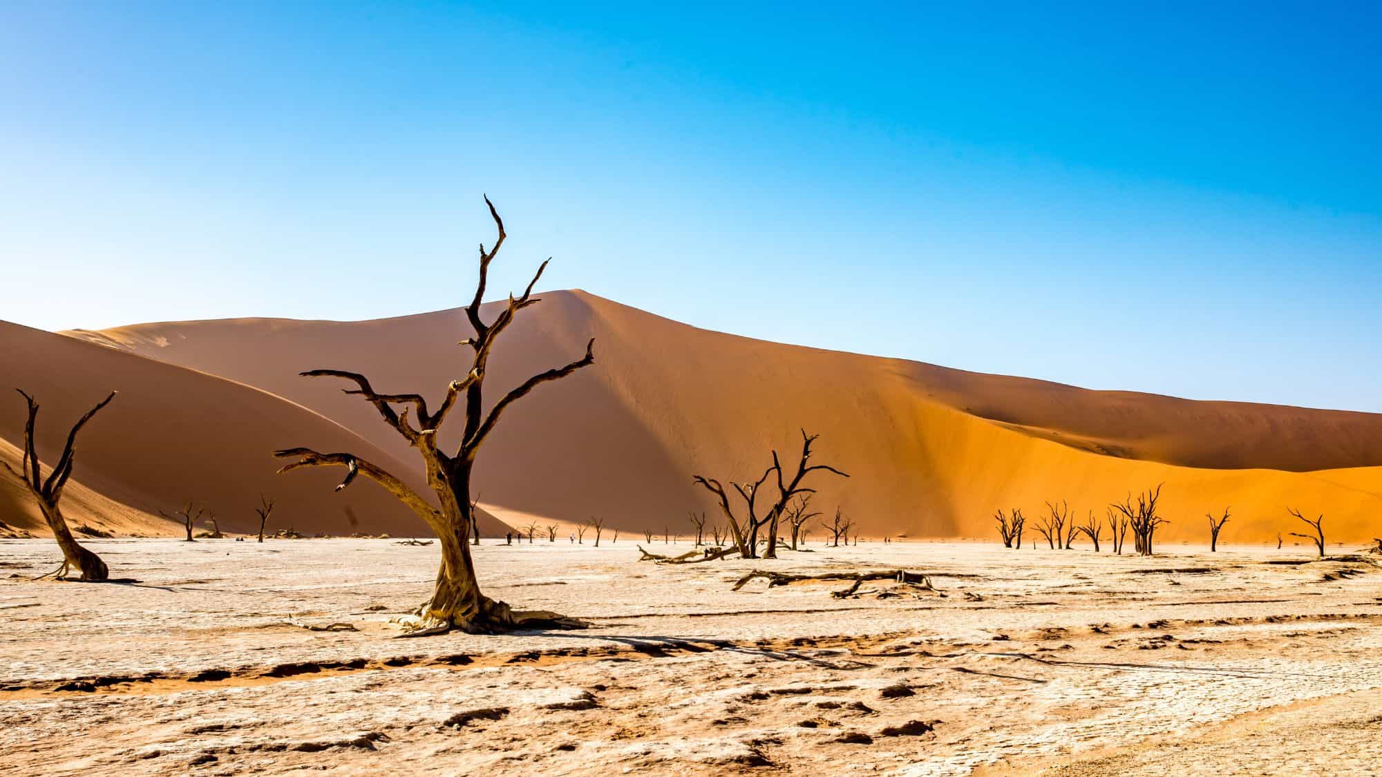
Hidden within Namib-Naukluft National Park are the skeletal remains of a forest that died centuries ago.
Deadvlei is a white clay pan surrounded by some of the highest red sand dunes in the world. Below, scattered across the cracked white floor, are the blackened trunks of camel thorn trees.
These trees are estimated to be between 600 and 700 years old. They died when the climate changed and drought hit the area, cutting off the Tsauchab River that once watered them. But the air here is so dry that the trees never decomposed.
Instead, they were scorched black by the intense sun, standing as dark monuments against the vibrant orange dunes and the deep blue sky.
It creates a landscape of stark, contrasting colors that looks more like a painting than a photograph. And climbing the surrounding dunes, like the famous “Big Daddy,” gives you a vantage point to see the full scale of the pan.
Ancient Sands Of Sossusvlei – Namibia

Sossusvlei is often grouped with Deadvlei, but the dunes themselves hold a separate mystery. The sand here is ancient, estimated to be around 5 million years old. The vibrant red color comes from iron oxide coating the sand grains, which essentially means the sand is rusting.
The older the dune, the brighter the red color, suggesting that these massive hills have been oxidizing under the African sun for eons.
These differ from regular dunes because of their stability and sheer size. Known as star dunes, they are shaped by winds blowing from multiple directions, causing the sand to pile up into towering peaks rather than shifting across the desert floor.
Some of these dunes reach heights of over 1,000 feet. So walking up the spine of a dune is physically demanding as the sand shifts under your weight, but the view from the top reveals a sea of red waves stretching endlessly.
The interplay of light and shadow at sunrise changes the dunes’ appearance by the minute, altering their shape and color in a mesmerizing display of fluidity.
Europe’s Wandering Dune Du Pilat – France

You might not expect to find a massive desert feature in the middle of lush France, but the Dune du Pilat defies expectations.
Located at the entrance to Arcachon Bay, this is the tallest sand dune in Europe, standing over 330 feet high. It is a colossal mountain of sand sandwiched between the Atlantic Ocean and a dense pine forest.
The contrast is striking, with the pale sand overtaking the dark green forest on one side and crashing down into the blue ocean on the other.
But what makes this dune particularly mysterious is that it is constantly moving. Driven by prevailing winds and tides, the Dune du Pilat migrates inland between 13 and 16 feet every year. It slowly swallows trees, road signs, and even buildings that stand in its path.
You can climb to the top using a staircase installed for visitors, or trudge up the sand if you want a workout. Paragliders also often use the updrafts here, soaring over a landscape that looks like a slice of the Sahara dropped onto the French coast.
Silence And Stars In Wadi Rum – Jordan

Wadi Rum is a protected area that covers 285 square miles of dramatic sandstone mountains and narrow canyons.
Known as the Valley of the Moon, it has been inhabited by human cultures for 12,000 years, evidenced by thousands of rock carvings and inscriptions.
The Bedouin people who live here today maintain a lifestyle that is intimately connected to this harsh environment. And spending a night in a Bedouin camp is the only way to truly understand the scale of the place.
At night, the lack of artificial light reveals a sky dense with stars. You sleep in tents made of goat hair or simple structures nestled against massive cliffs. The Bedouin guides share stories of the desert that have been passed down for generations, teaching visitors how to read the landscape.
The sheer verticality of the mountains rising from the red sand floor makes you feel incredibly small. It is a place where history and geology combine to create a cathedral of stone.
Three Worlds In Big Bend – Texas

Big Bend National Park presents a biological puzzle where three distinct ecosystems collide. The park encompasses the Chihuahuan Desert, the Chisos Mountains, and the Rio Grande River Valley.
You can start your day hiking through cactus-filled desert flats, climb into cool mountain woodlands filled with pine and juniper, and end the afternoon paddling down a river canyon with 1,500-foot walls. This convergence creates a biodiversity hotspot that is rare for arid regions.
The Chisos Mountains are particularly unique because they are entirely contained within the park, rising like an island out of the desert sea. This isolation has allowed specific plant and animal species to evolve and thrive here.
You might see black bears and mountain lions in the high country, then drive down to the river to see tropical birds and river turtles. The transition between these zones is sharp and startling.
In fact, the temperature can drop 20°F as you ascend the mountains, offering a refuge from the desert heat below. So it challenges the idea that deserts are hot, uniform environments. Instead, it’s showing how altitude and water can create pockets of life in even the driest places.
The Chocolate Hills Anomaly – Philippines
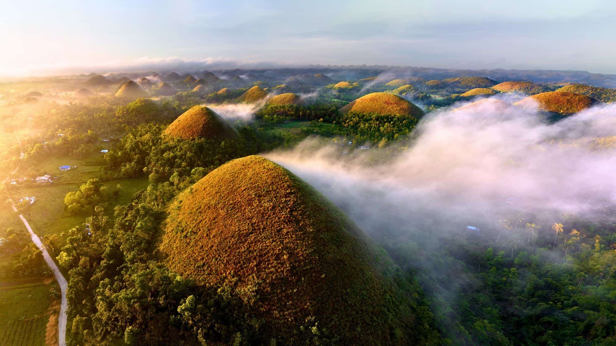
In the Philippines, the island of Bohol is home to a geological formation that looks too perfect to be natural.
The Chocolate Hills consist of between 1,268 and 1,776 conical mounds spread over an area of 20 square miles. These hills are remarkably symmetrical and uniform in shape, ranging from 100 to 160 feet high.
During the wet season, they are covered in lush green grass. However, in the dry season, the grass turns brown, giving them the appearance of giant chocolate kisses, which earned them their name.
Geologists classify these as karst formations. They were originally coral reefs and marine limestone deposits that were uplifted from the sea millions of years ago. Over time, rainwater and erosion dissolved the limestone and carved out the valleys between the mounds, leaving behind the cone shapes we see today.
The sheer number of them creates a rolling, bumpy landscape that extends as far as the eye can see. And viewing them from the observation deck in Carmen offers a perspective on just how vast and repetitive the pattern is.
Like Our Content? Follow Us on MSN (or click the Follow Button above) for more from Discover Parks & Wildlife.