Discover Parks & Wildlife contains affiliate links and is a member of the Amazon Services LLC Associates Program. If you make a purchase using one of the Amazon links, we may receive compensation at no extra cost to you. We may also use select AI tools to support our creative process, but all content is reviewed, refined, and finalized by our human team. See our disclosure policy and our AI use policy for more information.
Bucket List Challenge: 16 National Park Signs That You Need To Photograph In Your Lifetime
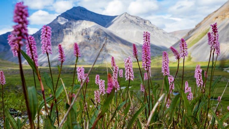
The open road stretches out before you, winding through changing landscapes that signal you are getting close to something magnificent. After hours behind the wheel, watching the scenery shift from city sprawl to wild horizons, you finally see it.
That brown and white arrowhead or the massive stone masonry structure standing guard at the roadside isn’t just a marker. It is a threshold. Pulling the car over to the shoulder becomes an instinctual reaction because standing next to that wooden slab confirms you have arrived.
These markers represent more than a boundary line between public and protected land. They serve as the opening chapter to the stories written in geysers, canyons, and ancient forests lying just beyond the gate. Collecting photos of these landmarks has become a tradition for road trippers everywhere, who measure their life in miles and memories.
Each one offers a tangible connection to the legacy of conservation that keeps these spaces wild. And standing next to one of these signs connects you to the generations of visitors who came before, all seeking the same sense of wonder.
Yellowstone National Park, Wyoming

When you approach the North Entrance of Yellowstone, you are greeted by something far more imposing than a standard wooden sign. The Roosevelt Arch, a massive basalt structure standing 50 feet high, serves as a grand ceremonial gateway to the world’s first national park.
Dedicated by President Theodore Roosevelt in 1903, the arch bears the inscription “For the Benefit and Enjoyment of the People,” a phrase that codified the mission of the National Park Service long before the agency was officially formed. The cornerstone was laid by Roosevelt himself during a visit that helped cement his legacy as a conservationist president.
This specific entrance in Gardiner, Montana, is unique because it is the only entrance to Yellowstone that remains open to wheeled vehicles year-round. While the other four entrances close to cars during the harsh winter months, the North Entrance provides consistent access to the Mammoth Hot Springs area.
Getting a photo here requires a bit of strategy, as the arch spans the active roadway, but pullouts allow you to safely admire the masonry. The sheer scale of the arch makes it difficult to fit in a single frame without standing back, emphasizing the grandeur of the 2.2 million-acre protected land waiting for you inside.
Capturing this structure is essential for any collector, as it represents the genesis of the national park idea.
Zion National Park, Utah

The entrance signs at Zion National Park signal a dramatic shift in geology, marking your arrival into a landscape defined by towering Navajo Sandstone cliffs.
Did you know that this park was originally designated as Mukuntuweap National Monument in 1909? It was renamed Zion in 1919 to make it more appealing to visitors, a marketing decision that clearly paid off, given its current popularity.
While the park has multiple entry points, the South Entrance near Springdale offers one of the most photographed markers, largely because of the breathtaking backdrop. The sign stands against a panorama of the Watchman and other peaks that soar thousands of feet into the blue desert sky.
Zion Canyon Scenic Drive, which runs 57 miles through the heart of the park, creates a visual journey that begins right at these boundary markers. The signs here often feature the classic National Park Service rustic style, using heavy timbers and stone bases that blend seamlessly with the red rock environment.
Because Zion creates a microclimate that supports diverse plant life, you might notice lush cottonwoods growing near the Virgin River just past the gate, contrasting sharply with the arid cliffs above.
The sheer verticality of the landscape visible from the entrance makes this specific location a favorite for photographers trying to capture the scale of Utah’s most famous canyon. And securing a photo here is often your last moment of solitude before joining the shuttle system that manages the millions of annual visitors.
Glacier National Park, Montana

Arriving at Glacier National Park feels like crossing a border into a different world, and in some places, you quite literally are. The park is part of the Waterton-Glacier International Peace Park, established in 1932 as the world’s first such union between two nations, celebrating the friendship between the United States and Canada.
The entrance signs here often sit in the shadow of glacial-carved peaks that rise abruptly from the plains, offering a preview of the dramatic topography you will encounter on the Going-to-the-Sun Road. This famous 50-mile engineering marvel bisects the park and crosses the Continental Divide at Logan Pass, but it all starts at the gate.
The West Glacier entrance sign is particularly iconic, surrounded by dense forests of cedar and hemlock that thrive in the moisture coming off the Pacific. And because the park contains the headwaters for streams that flow into the Pacific Ocean, the Gulf of Mexico, and Hudson Bay, standing at this boundary places you at a hydrological apex of the continent.
The sign serves as a reminder that the glaciers for which the park is named are retreating; in 1850, there were an estimated 150 glaciers, but today only 25 active glaciers remain large enough to be classified as such.
A photo here documents a landscape in flux. The distinct wooden signs, often framed by wildflowers in the summer or deep snowbanks in the shoulder seasons, act as a gateway to over 700 miles of hiking trails.
Everglades National Park, Florida

The entrance sign to Everglades National Park marks a transition into the largest subtropical wilderness in the United States.
This park is distinct because it was the first created solely to protect a fragile ecosystem rather than just scenic views, a shift in conservation philosophy that occurred upon its establishment in 1947.
Unlike the towering stone monuments of the West, the signs here are set against a backdrop of vast, flat sawgrass marshes and hardwood hammocks. Located near the Ernest F. Coe Visitor Center, the main entrance sign introduces you to a World Heritage Site that protects an ecosystem found nowhere else on earth.
When you stand next to this sign, you are entering a slow-moving river of grass that flows from Lake Okeechobee to the Florida Bay. The elevation changes here are measured in inches rather than thousands of feet, yet those inches dictate entirely different habitats.
The sign is often flanked by native vegetation that can survive the wet and dry seasons that define the region. You might notice the humidity immediately upon stepping out of your car, a constant reminder of the water that sustains the park’s famous biodiversity, including the American crocodile and the Florida panther.
Collecting this photo is a nod to the subtle beauty of the wetlands. It requires a different appreciation for nature, one that values the complexity of mangroves and marshes over the immediate drama of mountain peaks.
Great Smoky Mountains National Park, Tennessee & North Carolina

The heavy stone masonry signs of Great Smoky Mountains National Park reflect the craftsmanship of the Civilian Conservation Corps (CCC), which built much of the park’s infrastructure during the 1930s.
This park was officially established in 1934, created from lands that had been previously owned by timber companies and small farmers, making its return to wilderness a massive restoration project.
The park straddles the border between Tennessee and North Carolina, and signs at Newfound Gap allow you to stand with one foot in each state. As the most visited national park in the country, attracting over 12 million people annually, these signs see a constant stream of admirers.
The entrance signs are often shrouded in the blue-colored mist that gives the mountains their name. This vapor is actually released by the vegetation in the park, specifically the volatile organic compounds from the millions of trees.
The Oconaluftee entrance on the North Carolina side offers a grand introduction near the visitor center, where elk are frequently seen grazing in the open fields nearby. Because there is no entrance fee for driving the park road (there is one if you plan to stop within), you can drive right past the sign without stopping at a booth.
However, stopping for the photo is a rite of passage. The rugged stone design of the sign anchors the entrance against the rolling, forested ridges that stretch as far as the eye can see.
Capitol Reef National Park, Utah

Capitol Reef National Park is often the quietest of Utah’s “Mighty 5,” and its entrance sign reflects that sense of solitude. The entrance sign is typically set against the backdrop of the red Wingate Sandstone cliffs and white Navajo Sandstone domes that reminded early explorers of the U.S. Capitol building, giving the park its name.
While Zion and Arches draw the massive crowds, Capitol Reef offers a more introspective experience, and the sign is rarely crowded, allowing for a peaceful photo opportunity.
Located in the historic Fruita district, the surroundings of the sign offer a strange contrast: arid desert cliffs looming over lush fruit orchards planted by Mormon pioneers in the 1880s. You can actually pick and eat fruit from these heritage trees when they are in season, a unique activity within the National Park System.
The sign marks your entry into a geologist’s paradise where the earth’s crust has been buckled and twisted. And the contrasting colors of the rock layers (red, white, and gray) are visible right from the roadway near the entrance.
Capturing this sign proves you ventured off the main interstate path to explore the remote heart of southern Utah.
Guadalupe Mountains National Park, Texas

Rising abruptly from the Chihuahuan Desert, the sign for Guadalupe Mountains National Park stands before a towering limestone reef that was once underwater. Turns out, this park protects the world’s most extensive Permian fossil reef, a geological marvel that dates back 260 to 270 million years.
The sign itself is often dwarfed by the sheer vertical face of El Capitan (not the famous one in Yosemite), the prominent cliff that served as a landmark for stagecoaches and travelers for centuries.
The park is home to Guadalupe Peak, the highest point in Texas at 8,751 feet. And unlike many other parks that are designed for scenic drives, this is a hiker’s park, and the sign marks the beginning of some serious adventure.
Standing at the entrance sign, you are looking up at the “Top of Texas,” a stark contrast to the flat plains that surround the mountain range. The sign is relatively simple, usually wood on stone pillars, fitting the rugged and remote nature of the location.
Because the park is isolated (about 110 miles east of El Paso), getting this photo signifies a commitment to reaching the far corners of the NSP system. Just know that the winds here can be fierce, funneling through the Guadalupe Pass, so you might find yourself bracing against a gust while snapping the picture.
Grand Teton National Park, Wyoming

The entrance signs for Grand Teton National Park are famous for what they frame: the jagged, tooth-like silhouette of the Teton Range rising without foothills from the valley floor. The most prominent peak, Grand Teton, pierces the sky at 13,775 feet, creating one of the most dramatic mountain scenes in North America.
This park has a complicated history, having been established in 1929 but only expanding to its current size in 1950 after decades of political battling over land protection.
The signs here are often constructed with heavy timbers, echoing the western ranching heritage of Jackson Hole. When you stop at the sign, you are standing on the glacial outwash plain, a flat valley floor that accentuates the height of the mountains.
The Snake River winds through the park, providing a habitat for moose and bald eagles often spotted near the entrances. And the proximity to Yellowstone means many visitors hit both parks, but the Teton sign represents a different kind of alpine beauty. It’s sharper, steeper, and more condensed.
The photo here is a classic composition lesson, balancing the typography of the sign in the foreground with the granite peaks in the background.
In the fall, the cottonwoods and aspens surrounding the lower elevations turn brilliant gold, creating a stunning contrast with the slate gray mountains and the brown park sign.
Rocky Mountain National Park, Colorado

The Beaver Meadows entrance sign at Rocky Mountain National Park is a masterpiece of rustic architecture, utilizing massive logs and native stone that seem to grow out of the landscape.
The park itself is defined by extreme elevation, with Trail Ridge Road cresting at a dizzying 12,183 feet, making it the highest continuous paved road in the United States. And the sign acts as your final checkpoint before you begin the ascent into the alpine tundra, an ecosystem usually found in the Arctic.
The park contains over 60 mountain peaks that rise above 12,000 feet, providing a skyline that feels endless.
Established in 1915, the park has been a favorite destination for over a century, and the signs reflect a timeless quality. The wood is often weathered, showing the effects of the harsh sun and heavy snows that define the Colorado high country.
You will often see elk grazing casually near the entrance stations, unfazed by the traffic. The sign is not just a marker of territory but of altitude; passing it means you need to prepare for thinner air and rapidly changing weather.
It frames the Front Range of the Rockies, offering a promise of the continental divide views waiting at the top. Collectors prize this sign for the texture of the wood and the immediate sense of mountain scale it provides.
North Cascades National Park, Washington

North Cascades National Park is one of the least visited parks in the lower 48 states, making its entrance sign a rare prize for collectors. Often referred to as the “American Alps,” the park boasts over 300 glaciers, more than any other park in the U.S. outside of Alaska.
The sign is typically nestled among towering Douglas firs and western red cedars, reflecting the dense, lush forests that blanket the lower elevations. It feels secluded, often shrouded in the low-hanging clouds or mist that feeds the region’s massive waterfalls.
Because the park complex includes the Ross Lake and Lake Chelan National Recreation Areas, the boundaries can feel vast and interconnected, but the main park sign signals entry into a rugged wilderness with very few roads.
Accessing the heart of this park usually requires leaving the car behind, as there is very little road access compared to other parks.
The sign along State Route 20 (the North Cascades Highway) is your primary touchpoint with the designated wilderness. The road closes in the winter due to heavy avalanche danger, meaning this photo is strictly a summer or early autumn opportunity.
The contrast of the dark green forest, the white lettering, and the potential for snow-capped peaks peeking through the clouds makes for a moody, atmospheric image.
Bryce Canyon National Park, Utah

The entrance to Bryce Canyon National Park sits at a surprisingly high elevation, reaching over 8,000 feet near the visitor center, which means the air is crisp even in summer.
The sign often features the reddish-orange hues that match the Claron Formation rocks you are about to see. And it welcomes you to a geological oddity; despite the name, Bryce is not actually a canyon but a collection of giant natural amphitheaters along the eastern side of the Paunsaugunt Plateau. It contains the largest concentration of hoodoos (irregular rock formations) on Earth.
The park is also known for its incredibly dark skies and high visibility, often allowing you to see for over 100 miles on a clear day.
The sign marks the start of the 18-mile scenic drive that takes you along the canyon rim. Because the hoodoos are formed by frost weathering and stream erosion, the landscape is constantly, albeit slowly, changing.
A photo at the gate captures the moment before you look down into the amphitheater, a view that is often described as otherworldly. The ponderosa pines surrounding the entrance offer a green frame to the fiery colors of the rock.
Mammoth Cave National Park, Kentucky

The sign for Mammoth Cave National Park is deceptively simple, standing amidst the rolling green hills and thick forests of south-central Kentucky. But it guards the entrance to a subterranean world of immense scale; Mammoth Cave is the longest known cave system in the world, with over 420 miles of passageways surveyed and more still being discovered.
The sign is your only visual cue to the massive labyrinth beneath your feet, as the surface world gives little indication of the limestone caverns below. Designated as a UNESCO World Heritage site, the park protects not just the cave but the diverse river valley ecosystem above it.
The dense hardwood forest surrounding the entrance sign provides a lush, green canopy in the summer and vibrant colors in the fall. Unlike the western parks where the sign frames a distant mountain, here the sign is part of a tunnel of trees.
Taking a photo here is a study in contrasts: the bright, living forest above versus the absolute darkness and silence of the cave environment you are about to enter. It represents a journey into the earth itself, rather than across it.
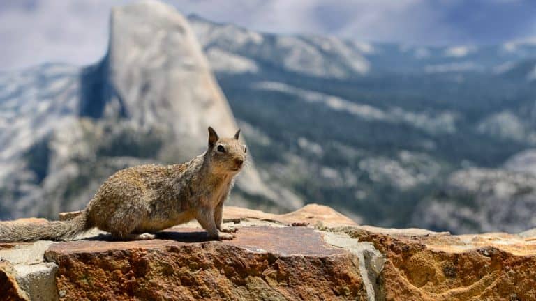
Yosemite National Park, California

Yosemite National Park offers several iconic entrances, but the Arch Rock Entrance is perhaps the most famous. Here, the road actually passes under two massive granite boulders, and the entrance sign is often photographed in conjunction with this natural gateway.
The signs in Yosemite are often built with heavy stone masonry, reflecting the geology that defines the park. Established in 1890, largely due to the lobbying of John Muir, Yosemite set the precedent for setting aside land for public preservation.
Yosemite is home to one of the tallest waterfalls in North America, Yosemite Falls, which drops a total of 2,425 feet. The park is a shrine to granite, featuring the monolithic El Capitan and Half Dome, which draw climbers from all over the globe.
In the spring, the Merced River rushes alongside the road near the Arch Rock entrance, swollen with snowmelt. The play of light on the gray granite and the deep green pines creates a specific color palette that is instantly recognizable.
Securing this image connects you to the history of photography in the park, following in the footsteps of Ansel Adams, who made these landscapes famous.
Saguaro National Park, Arizona

The entrance sign at Saguaro National Park stands as a sentinel in the Sonoran Desert, flanked by the massive cacti for which the park is named.
These giants are the universal symbol of the American West, yet they only grow naturally in this specific region. A saguaro cactus can live between 150 and 200 years and may not grow its first arm until it is 75 years old.
The park itself is unique because it is divided into two districts, the Tucson Mountain District (West) and the Rincon Mountain District (East), separated by the city of Tucson.
The park also protects the most biodiverse desert in North America, with the sign marking the boundary where urban sprawl ends and the protected wilderness begins.
You need a photo of the sign with a saguaro towering next to it to truly capture the essence of this park. The signs are simple, allowing the strange, human-like shapes of the cacti to take center stage.
It is a harsh environment of extreme heat and little water, yet life thrives here. The sign is a badge of honor for enduring the heat to witness the bloom of the desert.
Great Sand Dunes National Park, Colorado

Great Sand Dunes National Park presents one of the most surreal landscapes in the NPS, and the entrance sign marks the transition from high desert scrub to alpine peaks to massive sands.
What makes the sign special is the view behind it: the beige waves of sand piled up against the jagged, snow-capped Sangre de Cristo Mountains. This geological oddity was created by wind and water trapping sand in this pocket of the valley for millennia.
Originally a national monument, it was redesignated as a national park and preserve in 2004, making it one of the newer additions to the list. And it contains the tallest sand dunes in North America, with the Star Dune rising 750 feet from the valley floor.
The sign reflects the diverse ecosystem that includes wetlands, grasslands, forests, and alpine lakes. In late spring, Medano Creek flows at the base of the dunes, creating a beach-like atmosphere in the middle of Colorado.
A photo here captures a contradiction of textures (snow, sand, rock, and water) all in one frame. It is a remote park that requires a detour, so the sign serves as proof that you found this hidden corner of the Rockies.
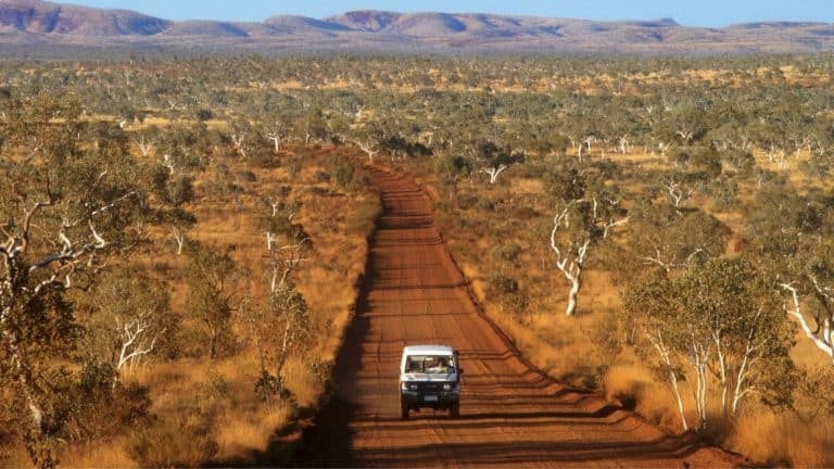
Big Bend National Park, Texas

Big Bend National Park is one of the most remote places in the lower 48 states, and reaching the entrance sign is an achievement in itself.
Located in the “Big Bend” of the Rio Grande River, which forms the border between the U.S. and Mexico, the park is a vast expanse of Chihuahuan Desert, river canyons, and the Chisos Mountains.
The Persimmon Gap entrance sign stands in a wide-open landscape where the scale of the sky feels overwhelming. It is often bathed in harsh, bright sunlight, emphasizing the ruggedness of the terrain.
The isolation is the point here; you are hundreds of miles from the nearest major airport. The park protects more species of birds, bats, and cacti than any other national park in the United States.
Standing at the entrance, you are looking at a landscape that has remained largely unchanged for centuries. And the sign is a gateway to that solitude, marking the entry into a place where the silence is heavy, and the horizon is endless.
Adding this sign to your collection shows you are willing to go the distance for wild beauty.
Like Our Content? Follow Us on MSN (or click the Follow Button above) for more from Discover Parks & Wildlife.